
Many locals, whether lifetime Raleighites or new citizens, have wondered about some of Raleigh's strange street names.
Where are the '"six forks" on Six Forks Road, and are there matching streets named Six Spoons and Six Knives?
Other WRAL Top Stories
What "mill" and 'brook' was Millbrook Road named after? Is there a real lead mine beneath Lead Mine Road?
Many of Raleigh's street names tell forgotten stories from Raleigh's history. Some street names provide clues to help unearth historic structures like underground mines, antique mills and lost farming communities.
Downtown Raleigh's earliest streets
When Raleigh was incorporated in 1792, there were nine commissioners in charge of choosing the land where Raleigh would be built who would help plan the city layout. Each commissioner had a street named after them. Their names should sound familiar to anyone who spends time downtown:
Frederick Hargett, William Dawson, Joseph McDowell, James Martin, Thomas Person, James Bloodworth, Henry William Harrington, Willie Jones and Thomas Blount.
The roads West Street, East Street, North Street and South Street marked the borders of the original 400 acres of Raleigh.
William Christmas, Raleigh's surveyor, named the streets surrounding the Capitol Building after North Carolina's eight judicial districts:
Wilmington, Fayetteville, Hillsborough, New Bern, Edenton, Morgan, Salisbury and Halifax.
Street names that point to abandoned historic remains or lost history
Raleigh has several street names that actually point to abandoned underground mines, forgotten historic mills, 200+ year old graveyards and even the remains of a theme park from 1912.
Let's explore the origins--and remaining hidden structures and tunnels--that relate to Six Forks, Millbrook, Lead Mine, Oberlin and Bloomsbury Park Drive.
Oberlin Road
The name 'Oberlin' now fits on a street sign, but it harkens back to an entire historic community called Oberlin Village. Some historic homes, churches and a graveyard from Oberlin Village still remain.
During the 1870s, in the immediate aftermath of the Civil War and emancipation, people who had been freed from local plantations formed the community of Oberlin Village, which was named after Oberlin College, an abolitionist college in Ohio.
Many freed people who lived in Oberlin Village came from the Cameron Plantation, for which the nearby Cameron Village now takes its name.
Six Forks Road
Many people have made jokes about Six Forks Road, saying, "Is there also a Six Spoons and Six Knives?"
Others have checked maps to see if the road itself has six major forks in the road as it winds its way across the city.
According to the Gazetteer, Six Forks Road is named after an old community in Northern Wake County that was named Six Forks, "near the head of Mine Creek, where six roads come together, formerly called Tippers Crossroads."
A document called the First and Second Order Triangulation and Traverse in North Carolina makes reference to Tippers Crossroads in 1934, saying it was about 8.5 miles north of downtown Raleigh and 4 miles northwest of Millbrook.
And is there a Six Knives or Six Spoons Road? There used to be.
Several readers who have lived in Raleigh for years responded to tell the story of Six Spoons Road and Six Knives Road.
Charles Uzzell said, "They were off Ramblewood Drive into the Tara Apartments."
Kent Parks said both roads were very short. According to Parks, the apartments have been torn down, and both roads are gone.
Millbrook Road
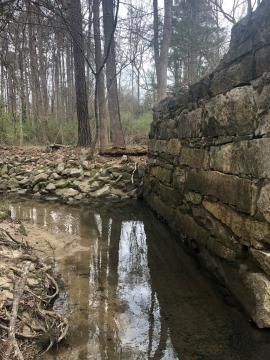
Millbrook Road is also named after a community that eventually faded from history after being annexed by Raleigh. Millbrook Road was named after the community called Millbrook Village that once neighbored Raleigh.
"In the early 1860s a community developed along US-1, six miles north of downtown Raleigh near an important gristmill situated on Marsh Creek," wrote Dr. Phil Ashburn of Millbrook United Methodist Church.
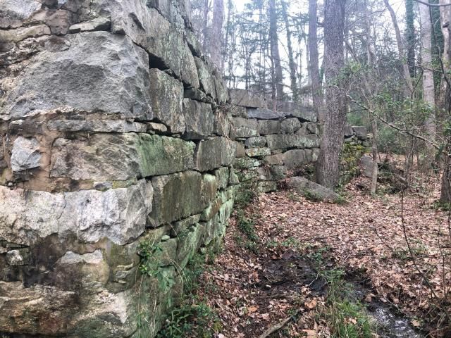
Remains of a mill were discovered in the back yard of a family living in the vicinity of this area, sitting on the banks of Marsh Creek. Some historians have theorized this structure is the original 'Mill Brook' for which Millbrook Village and Millbrook Road took their names.
"The well-hidden stone foundation is rumored to remain," wrote Ashburn.
Other roads in the surrounding area include Grist Mill Road, Old Forge Road, Harps Mill Road and Hunting Ridge Road. What old foundations and historic places might these road names recall?
Lead Mine Road and Saw Mill Road
Beneath Lead Mine Road there is a series of hidden graphite mines, many of which are still under the current Greystone Village neighborhood. Sawmill Road, which now connects Creedmoor and Lead Mine, was named for a sawmill located near the same area in Raleigh’s early days.
Julian Baker wrote a history of the land surrounding the mines on the Greystone Village website, saying, "Before the first development of North Raleigh, all of the land in this area was used for farming, pasture land, and timber for hundreds of years, and until the 1980's it was many miles from the city limits of Raleigh."
Baker described a sawmill located approximately where the cabin sits on Baker's Lake--thus the name "Sawmill" for the street which now connects Creedmoor and Lead Mine.
Bloomsbury Park Drive
Bloomsbury Park Drive is a short, dead-end road near the Carolina County Club. It's very easy to overlook.
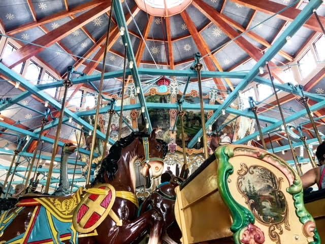
However, in 1912 an impressive roller coaster theme park with a dance pavilion, carousel and thousands of electric twinkling lights once stood on that land. Called Bloomsbury Park, it was Raleigh's own version of Coney Island, sitting near Five Points on the outskirts of the city, where the Glenwood Avenue trolley would turn around.
Some remains of the park can still be found in the neighborhood, including the platform where the trolley once turned around and a large segment of the dance pavilion. The park's carousel is still an active part of Raleigh culture--when Bloomsbury Park closed, Pullen Park purchased the carousel and kept it going.
Bloomsbury Park Drive is very likely named after the grand park that once stood there. Likewise, the name Bloomsbury very possibly came from one of Raleigh's original names. Before the City of Raleigh was established in 1792, the community of farms and plantations was known by several names, including Bloomsbury and Wake Courthouse.
Do you know any Raleigh road names with legends or mysteries?
So many of Raleigh's street names have history or legends attached to them. Are there any names we missed that you'd like to learn about, or share your own knowledge about? Let us know!
And the next time you're driving through Raleigh, take a closer look at the common street names you pass everyday. They may be telling you a story you never noticed before now.
Want to learn more about abandoned mills and ruins in Umstead Park from a farming community from the 1800s?
Here's an in-depth look at Fayetteville Street in the 1940s, including stores and shops that no longer exist and a truly Raleigh love story from a golden era.
Or explore the last remaining runway from one of Raleigh's first airports, Raleigh Municipal Airport. Segments of the runway built in 1929 harken back to days when Amelia Earhart herself flew over Raleigh.