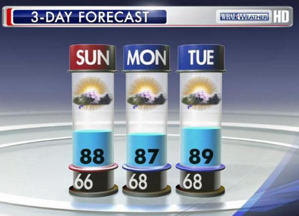
Clouds move in to Triangle Sunday
Sunday and Monday will bring more clouds into the area, but Memorial Day celebrations should remain mostly dry.
Posted — Updated


"We have a very slight chance to see isolated showers to our east Saturday night," WRAL meteorologist Aimee Wilmoth said.
Over night Saturday will very mild, cooling only into the mid-60s, before the mercury begins to rise again Sunday.
It won't get quite as warm, and the humidity will be more apparent, especially during the morning hours, the forecast shows.
Sunday afternoon could bring some widely scattered showers and even thunderstorms across central North Carolina.
"These storms will not be related directly to Beryl, but rather an influx of deeper moisture and instability from the Atlantic. While the cells will probably be rather hit and miss in nature, a few may produce locally heavy downpours," Wilmoth said.
The effects of that system are likely to come by mid-week. Forecast models show Beryl making landfall along the Florida-Georgia line late Sunday and moving inland before making another turn to the north.


• Credits
Copyright 2024 by WRAL.com and the Associated Press. All rights reserved. This material may not be published, broadcast, rewritten or redistributed.


