UNC-Chapel Hill professor maps likelihood of meeting someone with COVID in your neighborhood
As with real estate, location, location, location is often key to the likelihood of catching coronavirus and contracting COVID-19.
Posted — UpdatedThe state added 8,105 cases on Friday, marking only the fourth time during the pandemic that more than 8,000 cases have been recorded on back-to-back days. The other three times were in early January, when the state saw what is still the peak of the pandemic.
But as with real estate, location, location, location is often key to the likelihood of catching the virus and contracting COVID-19.
Some areas have high vaccination rates and lower infection rates. In others, it's the reverse.
Robeson, Columbus and Duplin counties in southeastern North Carolina, for example, all rank in the top 10 statewide for least vaccinated and most new cases in last two weeks.
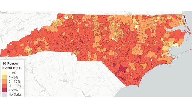
Paul Delamater, an assistant professor in the Department of Geography at the University of North Carolina at Chapel Hill, decided to figure out the chances of meeting someone with COVID-19 anywhere in the state.
"I wanted to understand my risk of running into someone who's infectious kind of out in my daily life," Delamater said. "I'm trying to understand kind of the relationship between cases that are reported and actual people who are infected."
In Chapel Hill's 27517 ZIP code, the chance is 4 percent in a group of 10 and 10 percent in a group of 25. In the 27615 ZIP code in north Raleigh, the risk is 11 percent in a smaller group and 26 percent in a larger one.
"Since it's based on the chance that just one person out of that whole group is currently infectious, the more people you bring into your group, the higher the chance just goes up, because you have more people there," he said.
Other maps take into consideration whether the groups are blended from adjacent ZIP codes.
Delamater said his modeling shows North Carolina has more infections now than when cases peaked in January.
"I'm very concerned about what's going on in the south part of the state, like Robeson County," he said. "In that region, it doesn't look good as far as the numbers go. I'm also really worried about the health care systems in that part of the state."
His research team is brainstorming about how to take immunity into consideration for another map. In general, he said, the maps already show how effective vaccinations can be to reduce the chances of running into an infected person.
Wearing masks and maintaining some distance from others in public are other ways to minimize the risk, he added.
Related Topics
• Credits
Copyright 2024 by Capitol Broadcasting Company. All rights reserved. This material may not be published, broadcast, rewritten or redistributed.


