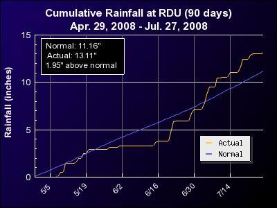
It can seem a little counter-intuitive given that much of our area has seen above normal rainfall over the past few months, including an almost 2-inch surplus over the past 90 days at the Raleigh-Durham airport (see the attached graph), but most of our area remains in a "moderate drought" designation from the U.S. Drought Monitor. While the periodic showers and thunderstorms have kept most reservoirs well-stocked with water so far (as of last night Falls lake stood at 251.3 feet, just below the guide curve, or normal, level of 251.5) there are still sufficient concerns with streamflows that rapidly fall to very low levels a day or two after rains abate, along with lingering low groundwater levels, to maintain that status.
The streamflow map here shows a few streams at near-normal flow in the wake of some scattered storms Sunday afternoon and evening, but a number in our area are still well below normal, and for much of the western half of the state (red and maroon dots in the image) flows are either in the lowest 10% of historical readings (maroon) or at the lowest levels on record (red). Real-time displays of groundwater level are few and far between across the state, but there is a site in Chapel Hill that is showing some improvement recently, but even so has just climbed to the upper borderline of the lowest 10% of levels on record there, as shown in the graph.
The most recent Drought Monitor map for the state shows that while we're not doing too badly in central and eastern parts of North Carolina, the western third of the state remains mired in extreme to exceptional drought, especially across the southern foothills and southern mountains. Some slow improvement appears possible based on climatological forecasts that favor near-normal precipitation for the next few months, but at least for the remainder of this week, it appears most shower and thunderstorm activity will be rather spotty in coverage and brief in duration, with temperatures that become hot enough to exacerbate evaporation rates, as we head into the mid and perhaps upper 90s at times.
Copyright 2024 by Capitol Broadcasting Company. All rights reserved. This material may not be published, broadcast, rewritten or redistributed.