Not the Hockey team in this case, but checking the paths of hurricanes and other tropical cyclones through history is made easier by a very nice resource provided online by the NOAA Coastal Services Center. It is a "Historical Hurricane Tracks" mapping database and viewer, and is an excellent tool for visualizing the track of storms.
What makes the tool especially useful is the ability to narrow your focus by searching for a particular storm, a particular county or state, a given month in a single year, all months in a given year, all years for a specific month, only storms of category four strength, etc, which allows slicing and dicing the climatological database in a nearly infinite variety of ways to suit the particular question at hand. For example, I recently answered an "Ask the Meteorologist" question that wondered if we'd ever had a hurricane make landfall in NC in the month of November. The database allowed me to search for storms from any year, passing through North Carolina, during the month of November. This quickly yielded the answer, and plotted the paths of the applicable storms in the process.
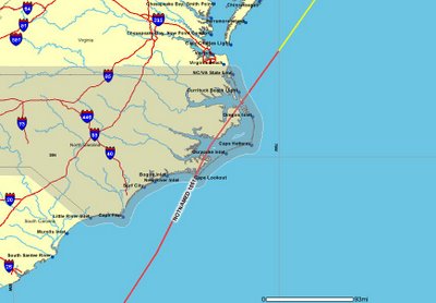
Incidentally, the only hurricane to make landfall here in November was on November 2, 1861, a category one system that cut across the Outer Banks and Sounds from southwest to northeast, in the process smashing up a Union Navy fleet sent to blockade the Carolina coast. Jay Barnes reports in "North Carolina's Hurricance History" that at least two ships sank, others were scattered about, and several wrecked on the NC coastline. Here's a map of that storm's path, returned by the database/viewer I mentioned above...