Thunderstorms roll through the Triangle
An approaching frontal system from the west that crept across the state Sunday mixed with an upper level trough to bring severe weather to the Triangle, lighting up the night with cloud-to-ground lightning, heavy rains and gusty winds.
Posted — Updated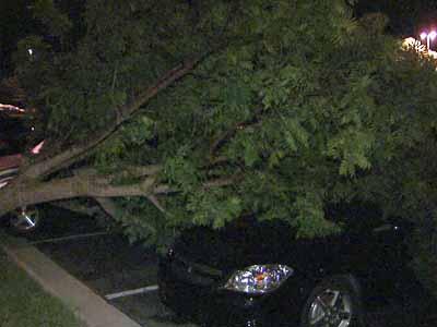
"We've been waiting and watching and (storms) arrived with a big bang," said WRAL meteorologist Kim Deaner.
A flash flood warning covered Wayne County until 1 a.m. Monday.
"This particular area has seen up to 3 or 4 inches of rain and flash flooding has been an issue," Deaner said. "Law enforcement is encouraging people to stay off the roads in flooded areas."
Storms rolling through the area produced strong wind gusts, knocking out power to nearly 16,000 Progress Energy customers in Cary, Raleigh and Garner, the utility said.
Orange County dispatchers reported a tree limb falling on a house. No one was injured and the house sustained no significant damage. Power lines and trees fell into the roadway on South Greensboro Street and Old Pittsboro Road in Carrboro, as well as Old Greensboro Road and Phils Creek Road in Chapel Hill.
In Cary, a tree landed on vehicles in the parking lot of the Embassy Suites on Harrison Oaks Boulevard. No one was hurt.
Earlier Sunday evening, a tornado warning was issued for Forsyth County, west of the Triangle. No tornado touchdowns were reported, however, according to the National Weather Service.
The chance for strong to severe storms diminished by Monday morning, which will be less humid. Highs will be in the upper 80s to around 90 degrees. Areas north and east of the Triangle could see an isolated afternoon storm.
The rest of the work week looks dry with highs in the upper 80s and lower 90s.
• Credits
Copyright 2024 by Capitol Broadcasting Company. All rights reserved. This material may not be published, broadcast, rewritten or redistributed.