
The hurricane drifted ashore Wednesday and began creeping up the coast, packing heavy rains and winds up to 115 mph. There were no early reports of widespread damage, injuries or deaths, though nearly a half-million tourists and residents had been ordered to evacuate.
Officials' next fear was that Bonnie would drop up to 20 inches of rain and cause widespread flooding in the eastern third of North Carolina.
``This hasn't done anything; this has just been going on longer,'' Dotty Freedland of Wrightsville Beach said Wednesday as she and her family shared a candlelit meal of raw fruit.
``The last one went on during the night,'' said Freedland, whose home sits on the Intracoastal Waterway. ``You'd watch it and go to bed and get up and it was over. This thing, we got up at 7 o'clock, and it's been going and it's been going on all day long.''
Hurricane Bonnie blew into the region with 115 mph winds, knocking out power to more than 300,000 customers, peeling the roof off one wing of a hospital and blowing a 40-foot section of windows out of a Wilmington high school.
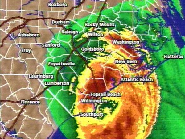
Bonnie's eye - the calm at the storm's center - came ashore at Cape Fear at 2 p.m. Wednesday. By 4 a.m. today it had moved barely 65 miles to the northeast. The top winds dipped to 100 mph before midnight, and then to 85 mph by 5 a.m., dropping to a category 1 storm from a category 3. Category 5 is the strongest.
Forecasters said the storm could linger over North Carolina for a day or more and bring up to 20 inches of rain.
``I suspect it's going to be raining very heavy for a long period of time and as it winds down,'' said Jerry Jarrell, director of the National Hurricane Center in Miami.
Bonnie was expected to reach Greenville, 100 miles north of Wilmington and much farther inland than earlier expected, by this afternoon.
Officials toured Wrightsville Beach Wednesday evening and found waters had crept about 18 inches into homes and businesses. Most of the damage was cosmetic, Fire Chief Everett Ward said.
``What we're referring to is this is a (Hurricane) Bertha event with a Fran flood, but it does not have the flood depth of the Fran event,'' Ward said. Bertha was the weaker of two 1996 hurricanes that followed paths similar to the one taken by Bonnie.
Hurricane Fran plowed through the middle of the state in September 1996, causing $5.2 billion in damage and 24 deaths. Even so, Bonnie, with its plodding pace and vast, 400-mile breadth, could wind up inflicting more damage than Fran.
Bonnie reached land early Wednesday afternoon at Cape Fear, near the South Carolina state line. It slowed from 16 mph to 8 mph and then spun, nearly stationary, for hours after it eased ashore. By midnight, rainfall amounts up to 7 inches had been reported, and forecasters said Bonnie could bring 15 to 20 inches of rain before moving out of the state.
The storm was expected eventually to veer to the northeast and move out to sea near the North Carolina-Virginia line, but North Carolina emergency officials said the storm could linger in the state through Friday.
Officials said Bonnie could raise water levels in some areas by 9 to 11 feet. Tide levels 9 feet above normal were reported in some areas Wednesday. The Pamlico River was reported over its banks at Washington in Beaufort County.
Bonnie ripped part of the roof from a small community hospital in Brunswick County, north of Cape Fear and forced the patients' evacuation. The storm moved over the Brunswick Nuclear Power plant, where reactors were shut down Tuesday.
The islands around Wilmington were under a 24-hour curfew. Wrightsville Beach Police Chief Joe Noble said about a dozen people were cited for violating the ban, including a Florida man who posed as a federal disaster official and led a group of reporters on a tour of the flooded island.
More than 16,000 people spent Wednesday night in 108 shelters scattered across 42 North Carolina counties.
The 19th-century lighthouse on Cape Fear's Bald Head Island sheltered 47 people.
West Carteret High School in Morehead City was converted into a shelter that lodged 200 people. Many brought sleeping bags, cots, blankets, radios, books and lanterns. Some of the refugees found familiar faces.
``We met each other during a storm years ago,'' said Iris Salter, who was chatting with Edwin and Gertha Lewis of Harker's Island.
Southport postmaster Marvin Watson regretted not getting off Oak Island before the only bridge closed Tuesday night.
``I'll tell you one thing - it's scary out there,'' he said as the wind pushed sheets of water across the island. ``If I had my choice right now, I'd be sitting over in Wilmington somewhere.''
While Bonnie reached the coast, Hurricane Danielle was weakening over the Atlantic 1,900 miles southeast of Miami. It was moving toward the northwest at 21 mph with winds of 85 mph that were expected to strengthen. Forecasters said it was too early to tell whether Danielle would threaten the U.S. mainland.
Copyright 2024 by Capitol Broadcasting Company. All rights reserved. This material may not be published, broadcast, rewritten or redistributed.


