Florence could once again be a major hurricane when it approaches NC
Forecasters are keeping an eye on Tropical Storm Florence, which has weakened but is expected to strengthen into a major category that could threaten the Carolinas towards the latter part of next weeks.
Posted — UpdatedWRAL meteorologist Aimee Wilmoth said Saturday that the track of the storm is still uncertain, but models continue to bring the system close to the North Carolina coast.
"With every update that we get, it looks increasingly like it's going to have an impact on North Carolina," Wilmoth said.
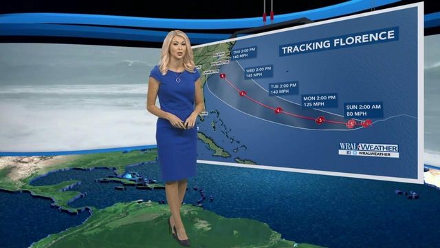
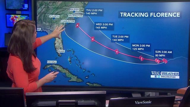
Florence could become a Category 3 storm again as early as Monday and will continue to get stronger as it approaches the East Coast.
“It’s got all the ingredients it needs to become a strong storm, a major hurricane, so we want you all to take this very seriously,” WRAL meteorologist Kat Campbell said.
Wilmoth said Florence has the potential to make landfall Thursday in North Carolina as a Category 4 hurricane with 140 mph winds.
"The forecast track just barely clips Raleigh, so we'll have to keep a closer eye on this forecast track, but the storm overall is moving very slowly," Campbell said.
Nearly all of the North Carolina and South Carolina coasts are included in the cone of uncertainty for the storm and the latest model Saturday night showed the storm making landfall in Wilmington.
Tropical storm force winds could begin along the coast Wednesday evening and have the potential to impact the Triangle. Raleigh has about a 30 percent chance to begin feeling the storm's impact by 8 p.m. Wednesday.
"This is a serious situation. We are going to be monitoring this very carefully," Wilmoth said.
Once the storm hits the North Carolina coast, Campbell said the slow moving system could cause significant flooding in addition to hurricane force winds.
From the 11 p.m. Saturday briefing by the National Hurricane Center:
- Tropical Storm Florence was moving slowly, but conditions were ideal for the storm to continue strengthening
- Parts of the Carolina coast could begin feeling significant impacts from the storm as early as Wednesday night.
- Florence is already causing rough surf and rip currents along the North Carolina coast
- Residents in North Carolina and other East Coast states should pay attention to the storm and begin to think about hurricane plans.
- Florence could be a Category 4 storm when it approaches North Carolina on Thursday.
The center is expected to issue another update Saturday at 11 p.m.
As of Saturday evening, Florence was a tropical storm that was traveling west at 6 mph with sustained winds of 70 mph.
Late Friday, North Carolina Gov. Roy Cooper declared a state of emergency.
“While it’s still too early to know the storm’s path, we know we have to be prepared,” he said in a written statement. “During harvest, time is of the essence. Action today can avoid losses due to Florence.”
Cooper's emergency declaration makes it possible to waive the state's transportation rules so North Carolina farmers can harvest and transport their crops to market faster.
Florence could cause dangerous surf and rip currents along parts of the U.S. East Coast this weekend as the storm swirls across the Atlantic, according to forecasters at the National Hurricane Center.
The National Parks of Eastern North Carolina issued a statement Saturday, warning beach visitors about the "dangerous ocean conditions."
"Large swells and high threats of rip currents associated with Tropical Storm Florence will produce life-threatening ocean conditions along Cape Hatteras National Seashore (Seashore) beaches," the statement said. "Due to these conditions, Superintendent David Hallac is strongly urging all beach visitors to stay out of the Atlantic Ocean until dangerous conditions subside."
Though weakened to a tropical storm, Florence was expected to regain hurricane strength as it neared Bermuda. Large swells were already expected to hit the British island territory in the north Atlantic Ocean Saturday.
More storms in the Atlantic
In the Eastern Atlantic the disturbance east of the Cabo Verde Islands has strengthened into Tropical Storm Helene, the eighth named storm of the 2018 Atlantic Hurricane season. The environment over the next few days was expected to support some further intensification. Helene will pass close to or perhaps over the southernmost Cabo Verde Islands Saturday night and Sunday. Gusty winds and heavy rainfall were expected this weekend for the island nation.
As the storm moves away from the Cabo Verde Islands later Sunday, it was expected to have the opportunity to become a hurricane. After passing the Cabo Verde Islands the system was not expected to pose a direct threat to land for at least several days.
Tropical Depression Nine formed 1755 miles east of the Windward Islands Friday.
Satellite images have shown gradual organization during the past 24 hours and the system should continue to develop through the next several days. Given sufficient warm water and low shear, Depression Nine should become a tropical storm sometime on Saturday. The favorable environmental conditions are expected along the path of this developing tropical cyclone and the system should become a hurricane during the early or middle part of next week.
The low pressure area that has formed into Depression Nine has moved very little during the past several hours. But it was expected to move on a mostly westward course during the next 24 hours. Then an almost due west path is forecast through the rest of the weekend and through early next week. The current projected path could bring this system over the Lesser Antilles during the latter part of next week.
Related Topics
• Credits
Copyright 2024 by WRAL.com and the Associated Press. All rights reserved. This material may not be published, broadcast, rewritten or redistributed.


