Heavy rain expected Thursday, tornadoes possible
A fast-moving, destructive storm system that has spawned at least nine tornadoes along the Gulf Coast may bring severe weather to central North Carolina Thursday morning, said WRAL Chief Meteorologist Greg Fishel.
Posted — UpdatedLight showers and overcast skies were expected overnight, but come 9 a.m., Fishel said, instability in the atmosphere could whip up storms, including possible tornadoes, throughout the area.
"We think that late morning into the afternoon is when the greatest threat of severe weather will be," Fishel said.
The system is likely to cause "a ballooning, a blossoming of precipitation," Fishel said.
The storm system will continue moving east and is expected to clear the area by late afternoon.
The chances for severe weather are best from the Triangle across eastern and coastal North Carolina.

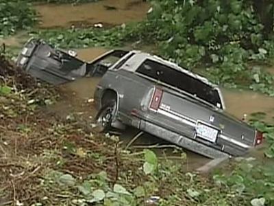
State Department of Transportation issued a warning about potential flash flooding and urged motorists to never drive through standing or rushing water.
The rainfall will likely total between 1 and 2 inches in central and eastern North Carolina. The mountains could see up to 5 inches.


• Credits
Copyright 2024 by Capitol Broadcasting Company. All rights reserved. This material may not be published, broadcast, rewritten or redistributed.


