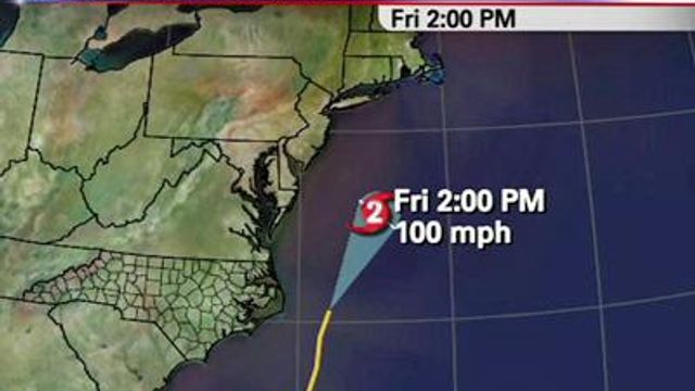
Earl prompts N.C. coastal evacuation
Tourists and residents have been ordered to leave one coastal North Carolina county, as Category 3 Hurricane Earl threatens to sideswipe the East Coast.
Posted — UpdatedHyde County declared a state of emergency around 9 p.m. Tuesday.
Early Wednesday, Hurricane Earl weakened to a Category 3 storm as its maximum sustained winds decreased to near 125 mph. But the National Hurricane Center in Miami says fluctuations in strength are possible over the next 48 hours.
Earl is about 815 miles south-southeast of Cape Hatteras and moving northwest near 16 mph.
Meanwhile, a hurricane watch issued Tuesday for North Carolina coast from north of Surf City to Duck was extended to the Virginia coast early Wednesday.
Emergency officials in North Carolina costal communities planned to meet Wednesday morning to decide whether evacuations were needed.
Cape Lookout National Seashore was also evacuating visitors and will be closed to the public starting Wednesday.
A number of visitor centers, including Ocracoke, Hatteras Island, Bodie Island, Wright Brothers and Fort Raleigh, will also close, as well as the Ocracoke, Frisco, Cape Point and Oregon Inlet campgrounds
The park service plans to close the Cape Hatteras Lighthouse with the last climb being at 2 p.m.
Earl was expected to remain over the open ocean before turning north and running parallel to the East Coast, bringing high winds and heavy rain to the Outer Banks by late Thursday or early Friday.
"If the storm tracks a little farther west, then all of a sudden, the impacts begin to increase significantly for the Outer Banks and the sounds," WRAL Chief Meteorologist Greg Fishel said. "It would take a pretty big shift in the track for there to be a major problem, farther south toward Wrightsville Beach."
New Hanover County officials said they were monitoring Earl and were ready should the forecast track change. They are mostly concerned with erosion and rip currents.
In neighboring Pender County, as well as Brunswick County, the moods were similar. Officials were topping off fuel and checking the readiness of generators that would come into play, if necessary.
From the Outer Banks, forecasters said, Earl could curve away from the coast somewhat as it makes it way north, perhaps hitting Massachusetts’ Cape Cod and the Maine shoreline on Friday night and Saturday. Forecasters cautioned that it was still too early to tell how close Earl might come to land.
Even if Earl stays well offshore, it will kick up rough surf and dangerous rip currents up and down the coast through the Labor Day weekend, a prime time for beach vacations, forecasters said.
“My guests are calling, and they don’t know what to do, and I don’t know what to tell them,” said Dave Dawson, owner of the oceanfront Cape Hatteras Motel in Buxton.
Not since Hurricane Bob in 1991 has such a powerful storm had such a large swath of the East Coast in its sights, said Dennis Feltgen, spokesman for the National Hurricane Center.
“A slight shift of that track to the west is going to impact a great deal of real estate with potential hurricane-force winds,” Feltgen said.
Meanwhile, the Federal Emergency Management Agency warned people along the rest of the Eastern Coast to prepare for possible evacuations if the storm does not veer away as expected.
“Today is the day to make sure you have your plan completed and your supplies in place,” FEMA administrator Criag Fugate said.
Close on Earl's heels was Tropical Storm Fiona, which had weakened considerably and not expected to get stronger at least for a couple of days.
Copyright 2024 by WRAL.com and the Associated Press. All rights reserved. This material may not be published, broadcast, rewritten or redistributed.


