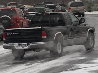
Black ice creates tricky travel
Temperatures in the teens plus leftover moisture from Monday's snow storm combined to create slick spots on the roads Tuesday morning. More than 70 counties across the state are under a winter weather advisory for black ice until 9 a.m.
Posted — UpdatedThe state's traffic alert system reported multiple crashes on Interstate 95 northbound in Wilson County around 6 a.m. Northbound traffic was blocked for a time at mile marker 120. It was was mostly cleared by 7 a.m., The state Department of Transportation's automated road-monitoring system still showed northbound traffic averaging 40 mph around the city of Wilson at 7:30.
In Chapel Hill, authorities reported black ice on:
- Weaver Dairy Road near the intersection with Martin Luther King Jr. Boulevard
- Old Durham Road near the intersection with Fordham Boulevard
- Intersection of Martin Luther King Jr. Boulevard and Hillsborough Street
"If you want to be super safe, take a cue from the schools and start out a little late," said WRAL traffic reporter Brian Shrader.
Temperatures 20 degrees below normal for this time of year were not helping the road situation, WRAL meteorologist Elizabeth Gardner said. Secondary roads, access ramps to major roads and bridges were the places ice was most likely to form.
"Our temperatures have dipped into the teens. We are definitely feeling winter's grip still," she said. "It is frigid this morning."
Not all ice problems were on the roads, either. One reader in Mebane said she had to chisel ice from the bottom of her garage door after melting snow from her car tires ran across the garage floor overnight and froze the door to the floor.
Meanwhile, Monday night, "an everlasting plume of snow" stretched along a line from Franklin and Warren counties through Rocky Mount and Goldsboro all the way to the coast, WRAL meteorologist Mike Maze said.
"Where did it come from? We got at least another inch, and it is still falling, wow!" WRAL viewer Lisa Hill, of Wilson, wrote in an e-mail. "The roads are coated, and it is an all-new winter wonderland."
Icy patches formed on Interstate 95, where wrecks blocked northbound lanes around Rocky Mount around 11 p.m.
Nash County dispatch officials said several wrecks occurred around mile markers 132 and 138. One wreck involved a horse trailer.
N.C. State graduate student Michael Grace said he wasn't looking forward to driving to classes Tuesday morning.
"It doesn't happen here a whole lot. And every time it does, it tends to turn to ice, so it's kinda bad news," he said.
In Wake County, a skeleton crew worked overnight and spread a sand-salt mixture on problem areas, officials said. Sand provides traction, and salt melts ice.
Chapel Hill officials said that all of the town's streets were passable Monday, but transit services could experience some delays due to road conditions Tuesday. Town workers spread 55 tons of salt on roadways Monday, officials said.
The Neuse River rose above flood stage in Johnston County Monday night. The river could cause minor flooding through Wednesday morning. At flood stage, the Neuse reaches the base of a 1 million-gallon water treatment plant in Smithfield.
An Arctic air mass will stick around North Carolina for at least one more day, but after it moves out, the cold weather will make a dramatic turnaround.
Temperatures will struggle to rise more than a few degrees above freezing Tuesday, and then "clear skies, light winds and a little leftover snow could make for a very cold night," WRAL Chief Meteorologist Greg Fishel said.
Wednesday will still be a little chilly, with a high in the upper 40s, but then the Arctic air moves out completely – and warm, southwesterly breezes flow in.
"The really good stuff gets here on Thursday as we get into the 60s and then 70s Friday and Saturday," Fishel said.
The Highway Patrol offered these tips to help drivers navigate slick roads.
- Clear your vehicle's windows and mirrors.
- Reduce your speed. Driving at the regular speed limit will reduce your ability to control the car if you begin to slide.
- Leave plenty of room between you and other vehicles.
- Bridges and overpasses accumulate ice first. Approach them with extreme caution, and do not apply your brakes while on the bridge.
- If you do begin to slide, take your foot off the gas, and turn the steering wheel in the direction of the slide. Do not apply the brakes as that will cause further loss of control of the car.
- Come to a complete stop or yield the right-of-way at intersections where traffic lights are out. Treat this situation as a four-way stop.
- If you have a cellular phone, take it with you. You can call the Highway Patrol statewide by dialing *HP (*47) or call the local county emergency center by dialing 911.
• Credits
Copyright 2024 by Capitol Broadcasting Company. All rights reserved. This material may not be published, broadcast, rewritten or redistributed.


