Forecasters: Will Fay falter in Tar Heel track?
The Triangle will stay dry and gradually will get warmer this week, and forecasters say that a high-pressure system may stall Tropical Storm Fay before it gets to North Carolina.
Posted — Updated
"It is too early to rule anything out, but it appears Fay may never have a great impact on North Carolina," WRAL Chief Meteorologist Greg Fishel said.
A high-pressure area building into the South from north will determine if North Carolina gets any rain from Fay when it moves away from the Florida Peninsula.
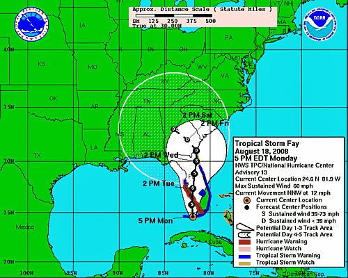
"Global models are in unanimous agreement" that the high pressure will bring Fay to "a grinding halt" over the Atlantic, Fishel said. Where the storm might stop moving is uncertain, but near the Florida-Georgia state line is a probable location, he added. The storm would then shift to the west.
If that scenario plays out, North Carolina "might not see a drop," Fishel said. "It looks like we could get off scot free."
The National Hurricane Center gives the state a 5 percent to 10 percent chance of getting tropical-storm force winds in the next five days.
At 3 p.m. Monday, Fay's center made landfall over Key West, Fla. It had maximum sustained winds of 57.5 mph, with higher gusts.
Earlier Monday, the National Hurricane Center had forecast that the high-pressure system would push Fay to the west as it tracked north inland. That would place the storm's center in western North Carolina early Saturday, possibly dropping several inches of rain in the mountains.
Officials said that so far this year, 20.16 inches of rain have fallen at Asheville Regional Airport. The normal amount is 30.57 inches.
State water-planning official Linwood Peele said drought conditions in western North Carolina came earlier than last year, and 2007 saw a record drought. The state's drought monitor lists 18 western counties in the most severe category, exceptional drought.
Tropical storms are good drought-busters, said Doug Miller, an associate professor of atmospheric sciences at the University of North Carolina at Asheville.
"We would almost have to have a repeat of the fall of 2004 to have a hope to get back to normal, and that was an exceedingly rare event," Miller said. That year, remnants of two hurricanes caused extensive flooding in western North Carolina.
If the westerly track predicted by most global models comes true, though, dry conditions could prevail over the Triangle for this week.
"If Fay stays away, we could have rain-free conditions here for the next week," Fishel said. He added that in an "ironic" move, Fay could bring remnant rainfall to the state in six to seven days.


• Credits
Copyright 2024 by WRAL.com and the Associated Press. All rights reserved. This material may not be published, broadcast, rewritten or redistributed.


 for 2024 season")


