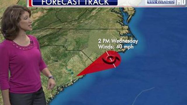
Beryl threatens rough surf at NC beaches
"Beryl won't make a direct hit on the North Carolina coast, but we'll need to keep watching it into the middle of the week," said WRAL meteorologist Aimee Wilmoth.
Posted — Updated"Beryl won't make a direct hit on the North Carolina coast, but we'll need to keep watching it into the middle of the week," said WRAL meteorologist Aimee Wilmoth.
At 3 p.m. Sunday, Beryl was about 110 east of Jacksonville, Fla., and 120 miles outheast of Brunswick, Ga. Its strongest sustained winds blew at 65 mph.
Ahead of the storm, dangerous surf conditions, including rip currents, kept North Carolina beachgoers on the sand.
"We're going to be flying red flags all of Memorial Day weekend into Monday due to the high surf and strong rip currents we're seeing out here," said Jeremy Owens, with NC Ocean Rescue in Wrightsville Beach. "We're advising all the swimmers to stay out of the water."
Any storms along the North Carolina coast will be hit-or-miss, Wilmoth said, and most days will see periods of both sun and clouds.
From northern Florida to southern South Carolina, Beryl could turn into "a three-day thunderstorm," dropping as much as 3 to 6 inches of rain, said Jay Wiggins, emergency management director for Glynn County in Georgia.
Those areas could see flooded roads, minor flooding in waterfront homes, scattered power outages and dangerous rip currents.
After making landfall, Beryl is expected to weaken while it's virtually stalled over Florida, Georgia and South Carolina until Tuesday afternoon. Then, another weather system will push it northeast quickly.
"That will take it across southeastern North Carolina, maybe just offshore or just inshore a little, and it could bring some rain that's fairly heavy to parts of the state Tuesday night into early Wednesday," WRAL meteorologist Mike Moss said.
The storm will move out into the Atlantic by Wednesday morning.
• Credits
Copyright 2024 by WRAL.com and the Associated Press. All rights reserved. This material may not be published, broadcast, rewritten or redistributed.


