Hail storms pound central NC
Low pressure that brought severe thunderstorms to an area south of the Triangle moved to the north Wednesday, bringing large hail, high winds and lightning strikes, WRAL meteorologist Mike Maze said.
Posted — UpdatedLow pressure that brought severe thunderstorms to an area south of the Triangle moved to the north Wednesday, bringing large hail, high winds and lightning strikes, WRAL meteorologist Mike Maze said.
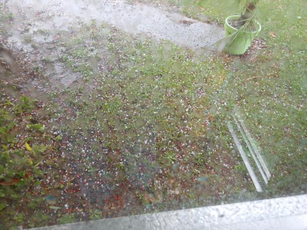
Residents from Raeford and Pinehurst north to Clayton and Raleigh reported hail at up to golf ball size that pelted cars and accumulated in grassy patches.
Damaging straight-line winds were also possible with Wednesday's storms, especially in areas along and east of Interstate 95.
While some saw storms, others were under sunny skies Wednesday afternoon.
"We're going to see these pop-up variety thunderstorms that fire up as our temperatures go up this afternoon," said WRAL meteorologist Elizabeth Gardner.
According to the National Weather Service, penny-and-dime-sized hail and winds of up to 45 mph were associated with storms that dumped heavy rain on the Triangle Tuesday afternoon.
"With the muggy air and warm temperatures, Wednesday's forecast is essentially a replay of what we saw yesterday," Gardner said. "Expect these storms to be dying out by 8 p.m. tonight."


The weather service posted a start watch, meaning conditions are ripe for severe weather, across the eastern half of the state through 9 p.m.
Thursday's forecast is similar, but showers and storms will likely be more widely scattered as high temperatures top out in the upper 80s.
By Friday, a ridge of high pressure will move into the area to set up beautiful weather for the holiday weekend. Temperatures could reach the 90s Saturday and Sunday, with much of central North Carolina seeing partly cloudy conditions.

• Credits
Copyright 2024 by Capitol Broadcasting Company. All rights reserved. This material may not be published, broadcast, rewritten or redistributed.


