Snow Not A Certainty
No one, and I do mean NO ONE, wants it to snow in Raleigh, NC more than I do, and the thought of it snowing later this week when I am up in Pennsylvania visiting my family sickens me to no end! However, for those of you that are true snow lovers like myself, I would be thrilled if all of you could get to witness a white landscape later this week.
Posted — Updated
No one, and I do mean NO ONE, wants it to snow in central and eastern North Carolina more than I do, and the thought of it snowing later this week when I am up in Pennsylvania visiting my family sickens me to no end! However, for those of you that are true snow lovers like myself, I would be thrilled if all of you could get to witness a white landscape later this week.
However, to base forecasts on what one wants to happen as opposed to what the best science suggests will happen, is nothing more than "wishcasting". I know, because I have been there many times. I cannot begin to tell you the number of instances much earlier in my career where I could give you 10 really good reasons why it would snow, but conveniently ignored the 15 equally good reasons why it wouldn't! But enough of my history-let's talk about this potential event later this week.
First of all, in order to get a storm to form in the first place, one needs a zone of temperature contrast, and the greater the contrast, the better. North Carolina has one such zone just off our coast, due to the proximity of the warm Gulf Stream waters. Heat from those warm waters is transported to the air above the water, and when bitterly cold air masses, like the one in place now, cover the adjacent land, an impressive gradient of temperature sets up along our coast, and is a breeding ground for coastal storm formation. However, many times this potential is not realized without the presence of what we call a "short wave" in the upper atmosphere. As these waves approach these zones of temperature contrast, storm formation is many times initiated.
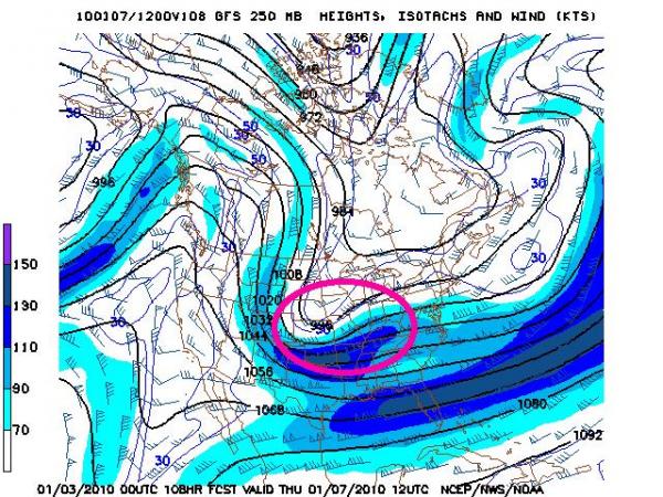
One way to look at these short waves is by looking at forecasts of the jet stream winds. I have attached 4 forecasts from the same computer model, all valid at the same time, 7am this coming Thursday morning. So, we are looking at 4 consecutive runs of a computer model, with each one 6 hours closer to the time for which the model is forecasting. So one might think that as you get closer to the time for which you are forecasting, the forecasts would get better and better, but that is not always the case. So, with that caveat, here goes.
This series of images shows a trend in the pattern of the winds at the jet stream level, with each successive model run showing a flatter flow, and the area of strongest winds at the jet stream level becoming more elongated. If these trends continue, it would be difficult to get a major snow event here in the Triangle later this week. An area of stronger jet stream winds concentrated over a relatively small region is called a jet streak, and ones position with respect to these jet streaks can have important impacts on who gets what. If the strongest winds are elongated over a large region, this becomes less and less of an issue.
One final note-the short wave we are watching is only now entering western North America. Data is fairly sparse over the Pacific Ocean, but is much denser over land masses. So, we should have a much better idea in the next couple of days how this wave is going to evolve, and what the resultant effects on North Carolina will be. As a famous politician once said, "Keep Hope Alive!!!"
Copyright 2024 by Capitol Broadcasting Company. All rights reserved. This material may not be published, broadcast, rewritten or redistributed.


