
For a few days in advance, we held some concern that there was a chance of severe weather across parts of our viewing area this past weekend, and in the end that was indeed the case. However, there was a surprise in store, as severe storms made an early appearance on Friday evening March 27, followed by a more isolated recurrence on Saturday the 28th.
While a number of tornado touchdowns were reported through the weekend in Cumberland, Sampson, Bladen, Robeson, Johnston, Greene and Pitt counties, which may have been associated with a total of four separate low-topped rotating storm cells, there were three tornadoes that rose to the level of being surveyed and reported on in detail by the national weather service offices responsible for issuing warnings.
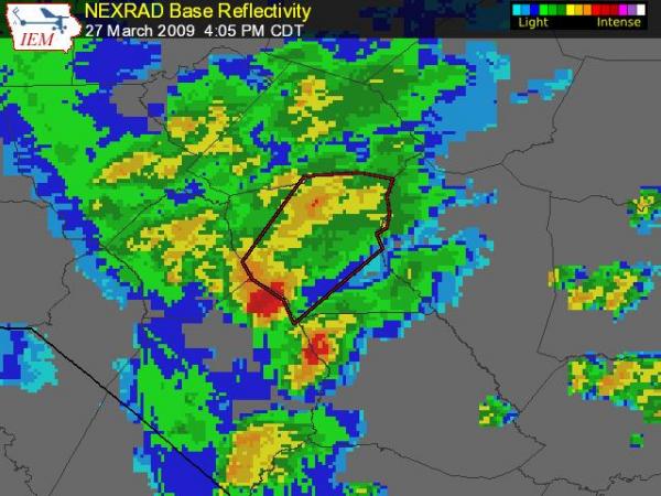
On Friday evening, a cell that moved out of northern Robeson county prompted a warning for much of Cumberland County (shown in the attached image from the Iowa Environmental Mesonet warning verification site, where the warned area is shown with a red outline over a map of radar echoes) and resulted in significant damage from a little south of Hope Mills to just south of the Fayetteville Regional Airport. On Saturday, the Raleigh weather service office sent a survey team out that reported in detail on the impacts of that tornado. The twister produced a damage path 5 miles long and 50 yards wide, with significant damage to several homes and at least one industrial site. Amazingly, one home that had 80% of its roof removed is on property where two previous homes have been destroyed by tornadoes since 1968. Given the relative infrequency of tornadoes in our state, and their tendency to be small, weak and short-lived in the great majority of cases, the odds of one home site being struck three times since the late '60s must be miniscule, yet for this one location they have turned out to be 100%! The storm survey rated this tornado at EF-1 on the enhanced Fujita scale, with estimated peak winds around 88 mph. See the "Cumberland Storm Survey" link for more details.
On Saturday evening, the highest impact system turned out to be a cell that crossed Bladen county, producing a tornado north of Clarkton that the Wilmington weather service office determined to rate EF-2, with a peak wind around 115 mph. It did substantial damage along a path that was a little over a mile and a half long and about 20 yards wide, including to one house in which the occupants took shelter under a staircase while their home was badly damaged around them. For more info, see the "Bladen Storm Survey" link.
While no one was injured along those tracks, there was an injury in northern Robeson County when a resident was caught inside her mobile home as it was dismantled by high winds. There is an affecting story from Renee Chou on the survivor that you can read or watch by searching our site for the terms "sewell mobile tornado" and choosing the "Couple Recounts..." link.
Finally, it was good to hear from some viewers who received notification about these storms either on the air or through the WeatherCall service. One aspect of WeatherCall is that it uses the newer "storm-based" warnings from the weather service to narrow the area warned down to a track along the storm's path, rather than the older method that would have placed all of Cumberland County under a warning for this storm, reducing the "false alarm" footprint if you will. In this case (again, see the image) northwestern and southeastern sections of the county were left out of the warning, reducing the area of the warning to about 66% of what it would have been otherwise. This is a big improvement, but of course still illustrates that tornadoes are such small-scale phenomena , with significant uncertainty about the exact track they will follow, that warnings by necessity have to cover much more area than the actual event. On Friday, the warning that you see here covered an area of 443 square miles (out of 658 total in Cumberland County) while the tornado damage path itself added up to .14 square miles, or about .03 percent of the warned area and .02 percent of the entire county.
Copyright 2024 by Capitol Broadcasting Company. All rights reserved. This material may not be published, broadcast, rewritten or redistributed.


