
We just finished off a mild weekend with temperatures that bracketed the "normal" of low 70s for the date, as RDU recorded highs of 71 on Saturday and 78 on Sunday. Our big weather influences for the weekend were a cutoff low aloft that meandered just to our south, finally weakening and drifting away to the southwest yesterday, and a large surface high over New England that began to intensify and build southward as the weekend progressed.
For the next few days, we'll continue to be influenced by that high as it settles in right over us and a bit to our west, and also an associated broad mid and upper-level high that will build across the eastern U.S. (see the first map of forecast 500 millibar heights from the Hydrometeorological Prediction Center, showing a well-defined ridge early Tuesday afternoon), inhibiting the progress of a sharp cold front that has been in place across the plains for the past couple of days. On the warm side of the front, and beneath that upper ridge, the combination of bright sunshine and subsiding air (which warms via compression as it sinks to lower altitudes with higher pressures) should push our temperatures way above normal, especially Tuesday through Thursday in the afternoon, and could threaten temperature records for those days. The current records for RDU are 86 on Tuesday, 88 on Wednesday and 85 on Thursday, all within a degree of our forecasts for highs for those days. Fortunately from a comfort standpoint, it appears we will see dew points remain in the low and mid 50s for the most part, representing pretty low values of relative humidity during the warmest parts of the day.
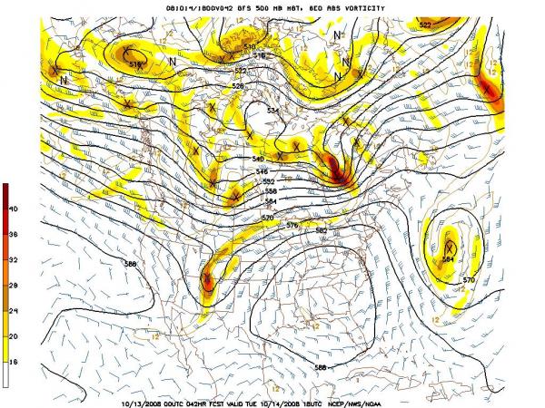
After all that mid-October heat (about 12-15 degrees above normal at a time of year when our standard deviation of daily highs is around +/- 8 degrees), we may be in for a big crash heading into the weekend, as the upper ridge is replaced by a trough of low pressure with its axis just to our east (see the 2nd image with a 500 millibar forecast for early Saturday afternoon). At the surface, this should mean a cold frontal passage late Thursday night or Friday, followed by a more substantial rush of cool air from the north late Friday into Saturday. As is often the case, there has been a little inconsistency and disagreement among model projections that far in the future (yesterday one of the models (GFS) made it seem we could stay in the 50s all day Saturday, but it looks a bit weaker with the cold air and precipitation now, while the European model has also trended in that direction) so there could yet be some adjustments in the weekend outlook. Nonetheless, we appear to be in for a 20 to 25 degree drop in our highs between Thursday and Saturday.
So, there should be a chance through the beginning days of the State Fair to choose whether you want to head out in some summerlike weather, with 80s on Thursday, or wait for more of an autumn feel, with weekend highs in the 60s.
Copyright 2024 by Capitol Broadcasting Company. All rights reserved. This material may not be published, broadcast, rewritten or redistributed.


 for 2024 season")


