The 2008 Hurricane Season: What's Left?
The worst is behind us. At least, climatologically. We're now a week past the peak of hurricane season, which climate records say is September 10th. After this, the likelihood that a storm will form begins to slide. But that doesn't mean we're out of the woods yet!
Posted — Updated
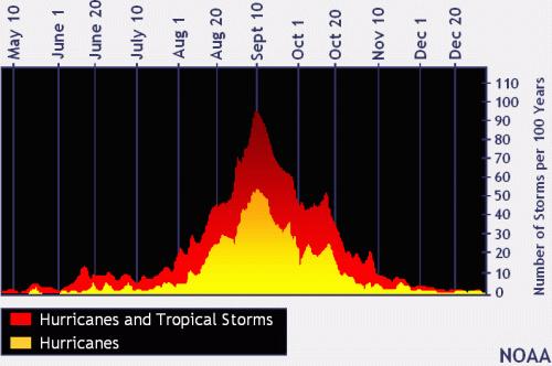
The worst is behind us. At least, climatologically.
- Fall weather patterns aren't as conducive to landfalling hurricanes along the southeastern coast of the US.
- Sea surface temperatures -- an indication of how much energy is available for hurricanes to grow -- begin to trend downward.
- The favored areas for tropical development shift to the Gulf of Mexico and Caribbean, both of which tend to favor storms that make landfall in the Gulf or re-curve back into the Atlantic before making landfall.
But that doesn't mean we're out of the woods yet.
Folks who have been in North Carolina for a long time remember one storm above all others: Hazel. While Fran (1996) and Floyd (1999) are the worst storms in recent memory, Hurricane Hazel is North Carolina's Katrina. According to the NWS, It made landfall near Wilmington on October 15, 1954, as a monster Category 4 storm, bringing winds of 140mph to Wilmington and 90mph to the Triangle. When it was all done, it had dumped 6-10 inches of rainfall and severely damaged or destroyed 50,000 structures across eastern North Carolina. Orrock says that if a storm of Hazel's magnitude were to strike us again, it would be "catastrophic".
Bottom line: We've weathered the worst of the season, but it's not over yet. Hurricane season runs through the end of November. No matter when the storms form, you can count on WRAL to track the storms from development to landfall and beyond.
Copyright 2024 by Capitol Broadcasting Company. All rights reserved. This material may not be published, broadcast, rewritten or redistributed.


