I'm surprised nobody on air has mentioned (as far as we have heard) yet the eerie similarities between Fran and Hanna in terms of date and timing. Sept 5/6, late night/early morning landfall. Looking at the pressure on your almanac page from those dates it crashed at KRDU around 4am. We'll see what happens tonight!
Posted — Updated
MIKE MOSS SAYS: Wally, Sorry I couldn't get to your comment before rather than after the fact, but it did come up a few times last week internally here and on the air as well that the timing would be pretty close to that of Fran twelve years ago. I still remember my drive to work that night, which took 45 minutes instead of the usual 8 at the time, very well!
As we all know now, of course, Hanna never gained the strength of Fran and also followed a path across our state with a centerline that was considerably farther east. While we saw rainfall amounts between 2 and 6 inches around most of our coverage area, along with wind gusts that ranged between about 30 and 55 mph, the overall impact of Hanna was far below that of Fran, with most of the flash flooding occuring in locations that commonly flood in heavy rain (parks, parking lots, athletic fields, etc, which are often placed in locations where it would be a bad idea to build homes, offices or stores) and damage/power outages due to falling trees pretty spotty. Not that it is much comfort to those few who had serious damage or those in the limited number of homes and apartments that flooded, of course, but the great majority of the area essentially ended up with a blustery, very rainy night and morning.
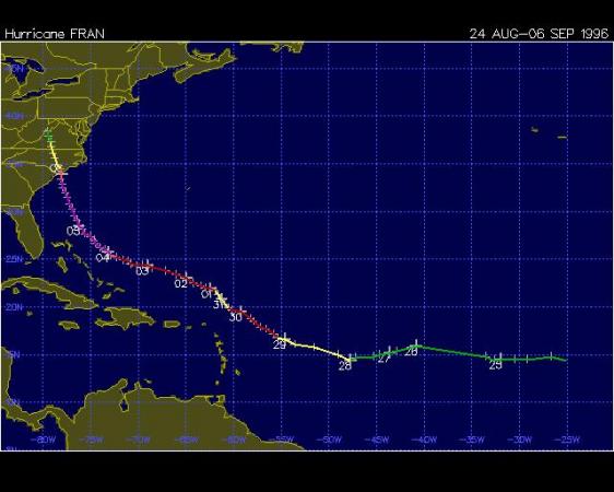
Just for comparison purposes, I am posting a track map from Fran and Hanna to show how they compared through their life cycle. As for the timing, it was pretty close - the center of Fran passed across the Raleigh areas around 3 am on Sep 6, 1996, and the center of Hanna passed by our same latitude (crossing Wilson County or thereabouts) more toward 8 or 9 am after landfall around 3:20 am this year. You'll note some significant differences on the tracks, in terms of where the storms spun up to "named" strength, the failure of Hanna to intensify nearly as much, the "detour" Hanna took in its loop-de-loop south across the lower Bahamas, and the storms' final angle of approach into NC.
Also, while the dates seem eerie, they are probably a bit less so than it would seem at a glance, since the last week of August through the first two weeks or so of September make for a fairly sharp peak in the historical frequency of tropical cyclones crossing North Carolina, so that it wouldn't be too unusual over the years for the same date to pop up from time to time!
Copyright 2024 by Capitol Broadcasting Company. All rights reserved. This material may not be published, broadcast, rewritten or redistributed.


