
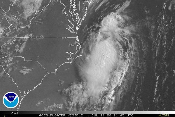
The weekend started with the formation of Tropical Depression Three off the southeastern coast of the U.S., followed pretty closely by intensification to tropical storm status and a slow northeastward brush along the coast of the Tarheel state. Cristobal followed forecast track and intensity rather closely and had minimal wind impacts along the coast, as the core of the tropical storm strength winds remained well southeast of the center and principally affected offshore waters. Most southern and central coast reporting station logged sustained winds in the 10-25 mph range through the weekend, with some gusts as high as 30-40 mph fairly common, and one 45 mph gust reported at Johnny Mercer pier in Wrightsville beach. As is often the case with tropical systems that parallel the coast, rainfall was mostly confined to areas near the coast and even there variety prevailed, with many areas receiving storm total rainfall on the order of one quarter to three-quarters of an inch (New River MCAS got .30" while Frisco picked up .56" for example), while some small pockets and streaks were much more heavily hit, with 2-nearly 5 inches over the weekend (3.46" at the Wilmington airport and 4.96" near Ogden, both n New Hanover County). Cristobal is accelerating away from the state today and should have little additional influence on the state.
The next storm, Dolly, has already formed and is tracking across the Yucatan Peninsula ( and yes, I resisted the temptation to put the name in the title where you see "Fayettevillle Doppler" above) before heading into the Gulf of Mexico, with a potential landfall in northern Mexico or southern Texas later this week. Oddly enough, this time last week it appeared that the precursor tropical wave that eventually became Dolly had a good chance to organize itself and become TD3/Cristobal, but it remained weak and poorly structured as it moved across the Antilles and eastern Caribbean, while the system that did become Cristobal spun up and "broke in line" as it were on the list of storm names.
One other bit of news that we've been pushing today and are excited about is the debut of a new live radar capability that we've put in place to scan the southwestern part of our viewing area with higher resolution, a lower beam height and and a more westerly location to enhance our interrogation of echoes approaching from the west and southwest. It will also to give us an alternate view angle of other cells when very heavy rain partially blocks a beam from other radars, or when an important cell happens to be passing through the "cone of silence" very close to or directly over the Dual Doppler 5000 and Raleigh NWS radars just southeast of Raleigh. This live radar should provide excellent coverage for Fayetteville, Fort Bragg, Pope AFB, Raeford, Carthage, Sanford and more, by placing the dish closer to those communities. We already had good coverage using the combination of our Live Dual Doppler 5000 system and near-real time displays from National Weather Service dopplers in Raleigh, Wilmington, Morehead City, Wakefield and Blacksburg, VA and Greenville-Spartanburg SC, but saw an opportunity in the Fayetteville and Sandhills areas to do even better, since that region was, on average, about the most distant from all the other radar sites. You can read more and access some videos about the Fayetteville Doppler by typing those keywords into our search form at the top of any WRAL web page, and you'll also find that our live streaming online radar display now shows sweeps and data from both systems.
Copyright 2024 by Capitol Broadcasting Company. All rights reserved. This material may not be published, broadcast, rewritten or redistributed.


 for 2024 season")


