
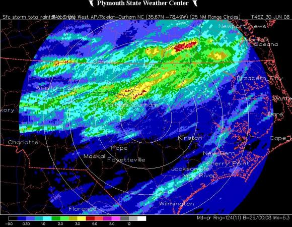
The deluge I'm talking about happened Sunday evening into Sunday night across roughly the northwestern third of our viewing area, with surface rainfall reports along a band from around the Triad into the northern Coastal Plain running in the 1-4 inch range, and radar estimates (see attached image) in good agreement with those readings. On the other hand, the showers and storms offered up relatively little rain south and east of a line from about Rocky Mount to Clayton to Southern Pines. So much rain in a short time will tend to help surface water supplies (rivers and reservoirs) a bit more than groundwater levels, but everything helps and this may go a ways toward preventing a worsening of drought conditions in the short term. Streamflows have been very low across central and western NC in recent weeks, but it's interesting to see how some streams are responding to the heavy rains last night. The second image attached, from the U.S. Geological Survey, shows a rapid increase in the flow rate (from about 1 cubic foot per second to over 30 in a matter of a few hours) of the Tar River in Granville County, but also shows how the river has been flowing well below the median rate indicated by the triangles on the graph. A similar spike is seen in the Eno River near Durham, but illustrated with the water level instead, which shot up from about 1 foot to almost 5, though it has already started to subside as the rapid runoff abates.
We have a chance at some more thundershowers later today, although coverage is tough to call because of competing effects of drier air aloft working its way into the area from the southwest, which would tend to make showers and storms less numerous, and an approaching upper level trough to our west, which would work in favor of forming some lines or clusters of activity.
Once that trough moves a little to our east later tonight , the main weather feature for the next two or three days will be a surface center of high pressure pushing in from the west. That system should bring lots of sunshine, temperatures that are a little cooler than the past several days, and perhaps most noticeably, a substantial drop in humidity. In fact, it wouldn't be out of the question to see dew points that have been in the mid 60s to near 70 at times over the past few days drop into the low 50s or even upper 40s by Wednesday (very low humidity for early July!) before we turn more muggy again toward the holiday weekend.
The character of that weekend also remains in some question at this point, as subtle differences between the two main medium range forecast models could make for a substantial difference in the weather that results. Both the Global Forecast System (GFS) and European Center (EC) models show a frontal boundary laying out along an east-west line and stalling across the eastern U.S. late this week and into the weekend, but the GFS stalls it right across our state, which would bring an increased chance of showers and storms, more cloud cover and temperatures in the 80s to around 90, while the EC stalls the front farther north, leaving our state with more sun, just a few isolated late day storms, and hotter temperatures in the 90s. It's a bit soon to favor one over the other (or some third alternate solution) as most likely to be more accurate - hopefully we'll have a convergence of solutions by midweek that will allow a more confident weekend forecast.
Copyright 2024 by Capitol Broadcasting Company. All rights reserved. This material may not be published, broadcast, rewritten or redistributed.


 for 2024 season")


