
We closed out the weekend with a closed upper level low drifting into North Carolina from the west, and the combination of plumes of moisture feeding in toward the system in the lower atmosphere ahead of the low along with fairly warm surface temperatures and cooling temperatures aloft led to enough destabilization to fire up some rather intense thunderstorms, some of which were aided by a jet streak over eastern NC and VA.
The overall pattern was one in which stability was decreasing and significant moisture was available (though concentrated somewhat into bands), and freezing levels were lowering from the west. It was a patern in which we expected some strong to isolated severe thunderstorms to form, with the main mode of severe weather being production of hail in the three-quarter inch to one inch size range. There did appear to also be a chance of some strong wind gusts or very isolated tornadoes, but that risk appered primarily to apply to the easternmost sections of NC and VA where wind fields and wind shear values were more favorable for those impacts.
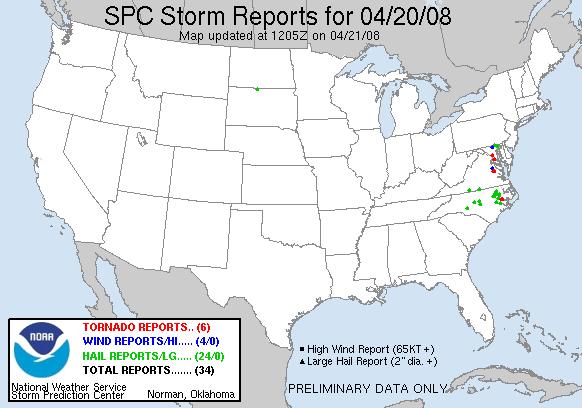
As it all turned out, there were a number of hail reports (green dots on the map) across our viewing area, with hail ranging from about pea-sized up to the size of quarters (around 1 inch). No wind damage was reported from any of the storms in our state, but there were two reports of tornadoes (red dots) from Beaufort County. These reports originated a little less than an hour apart from Chocowinity and the nearby Shady Banks area of Washington on the other (north) side of the Pamlico river. So far, no damage has been reported from those storms.
A few storms also organized themselves into training and back-building lines, especially across the northern I-95 corridor in parts of Halifax and Northampton counties, which resulted in some very heavy rainfall amounts along fairly narrow bands, prompting flash flood warnings for those areas.
We have received a few inquiries as to why we did not break into programming to cover these storms. It is often something of a judgement call, of course, but part of the process is to base the decision regarding pre-emption on the expected and observed nature of the storms. Since we had mentioned rather often in forecasts for the previous two days that Sunday afternoon would bring scattered storms, some of which would likely produce hail and gusty winds, and because the storms were mostly "following the script" as it were in producing hail but not wind damage, we chose, on a warning-by-warning basis, to limit our coverage to crawls across the bottom of the screen. Behind the scenes, of course, we were closely monitoring our radar and satellite systems, surface observations, storm reports relayed by the NWS and by Skywarn Spotters on Ham radio, and warnings and special statements issued by the local NWS office, and we stafed the WeatherCenter with two meteorologists throughout the event, when we usually are one-deep on weekends. Had we judged any of the storms in our local area likely to produce significant wind damage or especially large hail, a cut-in would have ensued. None of this is meant to imply that warnings relayed using only a crawl are not to be taken seriously. Any severe thunderstorm can be dangerous. An on-screen crawl is the basic means in which we can alert our viewers to their presence, while we attempt to reserve cut-ins to those situations that appear especially dangerous to life and property.
Copyright 2024 by Capitol Broadcasting Company. All rights reserved. This material may not be published, broadcast, rewritten or redistributed.


