Those Pesky Rainfall Deficits
Why do we focus on the rainfall deficit since the beginning of 2007? Why not reset the counter at the beginning of the year?
Posted — Updated
Many of you have asked the question "Why are you showing the rainfall deficit back to January 1 of 2007?" The simple answer is: Droughts don't develop and decay according to our calendar!
To be clear about this issue, we first have to start with the definition of "normal". The National Climatic Data Center (which by the way is located in Asheville, NC) defines "normal" as the temperature and/or precipitation averaged over a 30 year period. Currently, we are using the period 1971-2000, and our normals will not be updated until 2011, when we begin using the period 1981-2010. When the normals are updated, there are subtle changes based on the actual weather during the most recent 10 years, which will not be an exact match for the weather of the 10 years being dropped from the calculation. If the climate is fairly stable, one would expect above normal years to balance out the below normal years over this long of a period of time.
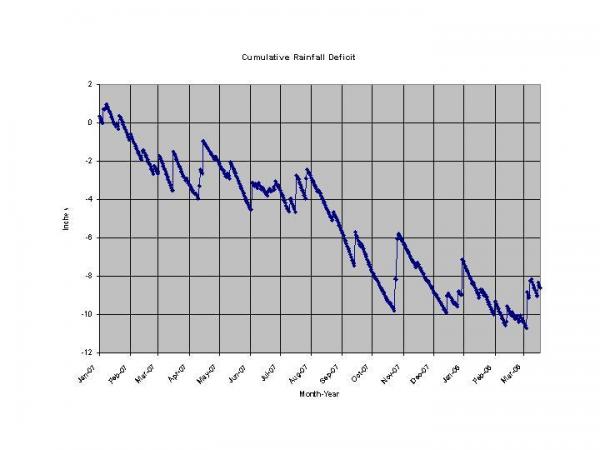
Droughts develop due to a cumulative deficit of rain over a long period of time. For the year 2007, we ended up 7.24" below normal. Through March 17th of 2008, our deficit dating back to January 1, 2007 is 8.58". So, over the first 76 days of 2008, our deficit has continued to decline. One cannot wipe the slate clean on New Years Day, and suddenly claim that the prior 365 days meant nothing when they mean everything. You can really see that by looking at the rainfall deficit graphically. When we've gotten significant rains, the deficit gets a little better, but overall, it has continued a steady march in the wrong direction.
Have our recent rains helped? You bet! This week is the first one since August 14. 2007 where not one county in North Carolina is under the classification of "Exceptional Drought". Still, 82% of the state is currently classified as being in either an extreme drought or a severe drought. So, the atmosphere still has a lot of work to do, but the recent relatively wet spell gives us some hope that perhaps the pattern is trying to change for the better. The graphs also hint at that -- the deficits are still trending "worse", but not quite as fast as they were for much of last year.
In any event, the National Weather Service and the NC State Climate Office both use the same evaluation standard we do, and that is to look at the deficit over the time period from when the drought began, to when it ends, whenever that may be. Our best bet is to continue to be water smart -- and THINK RAIN!!!
Copyright 2024 by Capitol Broadcasting Company. All rights reserved. This material may not be published, broadcast, rewritten or redistributed.


