
We finished out last week and started the weekend with a very active pattern involving a pair of surface low pressure areas and a pair of upper level disturbances that combined in a fairly complex manner to bring a second round of welcome rainfall during the past several days, and then left us with some roaring winds at times on Saturday as a departing low pressure center deepened, while high pressure moved into place to our southwest.
That combination led to a very steep pressure gradient between the low and high centers, which further led to very strong winds that surged and subsided from time to time on Saturday, eventually peaking with brief wind gusts as high as 52 mph at the Raleigh-Durham airport and 53 mph at Fayetteville and Rocky Mount. A number of other locations around the region recorded peak gusts in the 43-53 mph range as well. Note that a "gust" here is a more or less instantaneous value of wind speed (actually averaged over 3 seconds, but that's pretty close to instantaneous) while a sustained wind is averaged over a two-minute window. Typically over land in a situation like we had on Saturday, the peak gusts are about 1.5 to 2.5 times the sustained values. As a couple of examples, at 3 pm the RDU airport reported a west winds at 30 mph sustained, gusting to 45 mph, while at 7 pm the wind was 13 mph, gusting to 25 mph. For more on how winds are measured and reported, see an older post at www.wral.com/weather/blogpost/1283652/.
Some of the higher gusts on Saturday managed to break off a few branches and even topple a few trees, with some scattered power outages and road blockages as a result. In a few instances, trees fell on homes or mobile homes and caused some damage. Typically, there isn't much direct damage to homes or businesses from winds in the 40-50 mph range, but a weakened tree, or one with shallow roots in wet soil, can cause problems, as can flying debris if some lighter objects outdoors are unsecured. One other issue that comes into play with trees is how much of a target they present to the wind. Gusts into the lower 50-mph range can be a bit more of a problem if trees are laden with leaves that catch more of the wind's force, but usually less so in winter when the branches are bare of all those little "sails." Even so, winds like Saturday can certainly set the trees swaying to an impressive degree, and I found myself mesmerised a time or two watching the treetops toss around near my house.
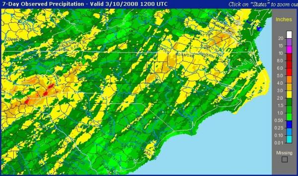
The other impact of the recent storms has been some significant and welcome rainfall. In the past week, the Raleigh-Durham airport totaled up an impressive 3.22 inches, and while there was some variation about the area, for once a lot of rain (see the 3-inch plus area on the 7-day rainfall map above) did manage to fall into the upper Neuse River watershed that feeds several area reservoirs. The response has been notable, with Lake Michie (2nd image) topping out at its "full" elevation of 341 feet, up almost 11 feet since early February. At Falls Lake (3rd image), the well-placed rainfall has pushed the level up by a little more than 4 and a half feet in the past 5 days.
It does appear we're in for a less active week ahead, with our next chance at measurable rainfall most likely on Friday or Saturday, but associated with what may turn out to be a faily poor rainmaker compared to the recent systems.
Copyright 2024 by Capitol Broadcasting Company. All rights reserved. This material may not be published, broadcast, rewritten or redistributed.


