Weather

A Saturday Wind Whipping (Through the) Trees

A storm system departing the area will kick up strong winds on Saturday, causing perhaps more damage than we saw duing last Tuesday's severe weather.

Posted Updated
WeatherScope Prediction for 1pm Saturday
By
Nate Johnson
Our much-ballyhooed storm system, now spinning across northern Alabam, may still kick up a few rumbles of thunder while you're trying to sleep in on Saturday, but it will be the winds that follow that will get your attention.

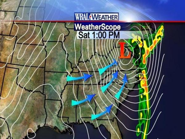
The surface component of this system will be taking shape across our area as it moves northeastward, and the more it develops, the tighter the pressure gradient will be come.  That gradient is the difference in atmospheric pressure between two points divided by the distance between those points.  The larger or "tighter" the gradient, the faster the winds will blow.

Look at it this way.  Imagine that the area of low pressure that will affect us tonight and tomorrow is a valley, and the area of high pressure that will move in behind it is a tall hill.  All other things being equal, if the "hill" of high pressure and the "valley" of low pressure are very close together, the side of the hillside inbetween will be very steep.  On the other hand, if they are far apart, the hillside will be gently sloped.

Saturday, the high pressure "hill" and low pressure "valley" will be very close together, and the "valley" itself will be getting progressively deeper as the day wears on.  Much like a ball released at the top of the hill, the winds will blow very fast to get from the top of the hill to the bottom of the valley.

Those of you who follow the weather regularly have heard Greg or others talk about how the wind usually blows nearly parallel to the isobars, or lines of equal pressure.  Wind usually blows from areas of high pressure to areas of low pressure, but it's deflected to the right (in the northern hemisphere) due to the rotation of the earth.  When those two components are in proper balance, the winds will blow nearly parallel to the isobars.
Saturday, though, will be one of those rare situations where the wind will tend to blow across the isobars to a large degree.  This is because -- to go back to our hill-and-valley analogy -- the hill is growing taller with time and the valley is growing lower with time.  That's adding speed to the mix that isn't being balanced by the rotation of the earth, causing the wind to blow across the isobars.
The end result of all this will be a very windy afternoon Saturday, with sustained winds 20-30mph and gusts of up to 50mph possible.  Since much of the ground is very moist due to recent rainfall, all of this wind energy will likely be enough to blow a few trees over, so be careful out there.  With that in mind, the National Weather Service has issued a Wind Advisory for our area on Saturday.
Sunday and early next week all look sunny, cool, and -- compared to Saturday -- calm.  (Don't forget to change those clocks!)

More On This

Copyright 2024 by Capitol Broadcasting Company. All rights reserved. This material may not be published, broadcast, rewritten or redistributed.