
Climate statistics are in for the month of February (and with it, the "meteorological winter" of 2007-08). At the Raleigh-Durham airport, we ended February with a mean temperature for the month of 48 degrees, about 5 degrees above normal, and recorded 3.16 inches of precipitation, only a trace of which fell in the form of snow. There were two days with new record high temperatures, with 76 on Feb 5th and 77 the following day, and we had one new record high minimum temperature, when we only fell to 61 degrees on Feb 6th. At the Fayetteville airport, the mean temperature for the month was 50.8 degrees and the monthly precipitation was 3.7 inches.
For the winter season, we closed out with an average temperature at RDU of 46.0 degrees F, which is 4.1 degrees above normal for the period, and recorded 8.87 inches of precipitation. That's 1.66 inches below normal, meaning at the airport we ended up with about 84% of normal rainfall for the season. It was a weak winter in terms of snowfall, as we only recorded one-half inch of snow, about 6.2 inches below the long-term average. It's worth noting, though, that the long term snowfall average is based on a highly variable record, and years with little or no snowfall are not all that uncommon, particularly over the past 15-20 years (and also in the late 40s to mid 50s or so).
Overall then, this turned out to be a rather accurately projected winter scenraio for our region. Here is part of an "Ask the Meteorologist" post I wrote back on Dec 15th, 2007, regarding prospects for snow during the winter...
"During the latter half of this year, a La Nina (cooler than normal sea surface temperatures across the eastern equatorial Pacific) has developed, gradually strengthening from weak to moderate intensity, and now forecast to be moderate to strong for the winter season. Historically, this tends to produce a pattern in which some upper level ridging is fairly common across the southeastern U.S. while upper level troughing and surface storm tracks are diverted a bit to our northwest. This leads to a seasonal tendency for temperatures to run warmer than normal in NC (especially central and eastern parts of the state) and for precipitation to trend below normal, while precipitation tends to be enhanced from about the mid-Mississippi Valley into the Ohio valley area. That is the current outlook from the Climate Prediction Center for the Dec-Feb winter period this season."
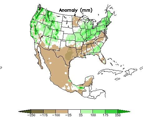
So, the folks at the Climate Prediction Center did well with their outlook, and the patterns favored by moderate to strong La Nina conditions pretty much held true. This isn't always the case, as illustrated by the strong La Nina of winter 2000, when we had the 20+ inch snowfall in our area. The attached image gives a nice overview of the winter precipitation distribution for this year. You'll notice much of the southeast ended up with below normal precipitation (brown shading), while the Ohio valley and surrounding areas to our northwest saw above normal amounts. One area where the La Nina tendencies did not fully hold true was the streak of above-normal rainfall from about the Florida Panhandle into eastern South Carolina. On average for moderate to strong La Nina events, that area actually has the greatest departure from normal toward the dry side.
Copyright 2024 by Capitol Broadcasting Company. All rights reserved. This material may not be published, broadcast, rewritten or redistributed.


