
... As has been the case several other times over the past year or so, another storm system has brought most of its precipitation to the southeastern half or so of our viewing area, while producing rather meager rainfall amounts fo the upper reaches of the Neuse River watershed that feeds into Falls Lake and, farther upstream, the Little River and Lake Michie reservoirs.
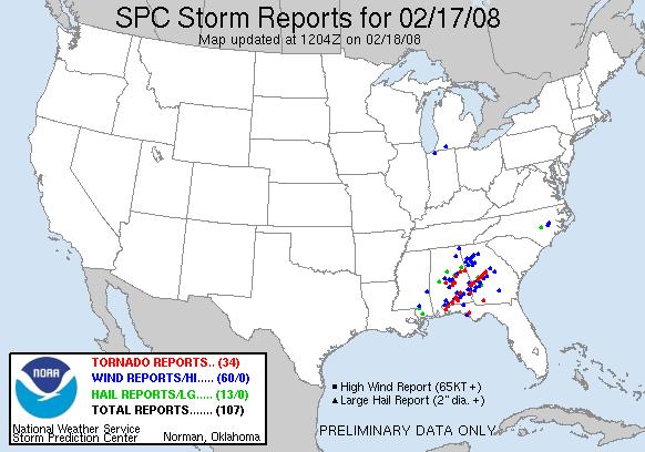
A frontal system that brought a sizable outbreak of severe weather southwest of us on Sunday (numerous reports of wind damage and tornadoes for Alabama and Georgia - see the map above) moved across the Tarheel state Sunday night into early Monday. While several severe thunderstorm and tornado warnings were issued across southeastern parts of our area, from around Robeson and Cumberland Counties over through Wayne County, a lack of instability appears to have limited the impacts at the surface, as preliminary reports do not include observed severe impacts in those locations, with the exception of some penny-size hail near the northern border of Sampson county. There were a couple of additional reports of damage just east of our viewing area, with several light poles snapped by wind near LaGrange in Lenoir County and a more serious report from the Snow Hill area in Greene County involving two mobile homes that lost roofs and a two story house reportedly leveled.
The system brought a wide range of rainfall totals to the region, with some streaks of very heavy rain where the most intense thunderstorms rolled through, and more modest amounts reported over a larger area. Some measured amounts as of 8 am on Monday (we may add a little to some of these totals before the system completely moves out) included .07" at Greensboro, .10" at Burlington, .27" at Raleigh-Durham airport, .36" at Roanoke Rapids, .44" at Sanford, .51" at Rocky Mt-Wilson airport, and 1.11" at Fayetteville. Much more copiuous rain was reported at Lumberton (2.24"), Seymour Johnson AFB in Goldsboro (2.86") and Clinton (3.43"). You can see the pattern in these numbers that I mentioned at the top of the post, with lower amounts concentrated toward the northwestern half of our viewing area and vice versa. A storm total rainfall estimate from the NWS Raleigh NEXRAD radar (from the Plymouth State University web site, second image above) illustrates that distribution, in addition to the southwest to northeast movement of the heavier showers that tracked across the area.
All of this came with a warm, moist airmass in advance of a pair of cold fronts that will sweep in and bring noticeably cooler air for Tuesday, before a moderate warmup on Wednesday, and then another big cooldown for later in the week.
Copyright 2024 by Capitol Broadcasting Company. All rights reserved. This material may not be published, broadcast, rewritten or redistributed.


