
Let's hope the title of the old Paul Simon tune isn't a good description of Tuesday morning around the region, but there are signs of a chance at some patches of freezing drizzle or light freezing rain developing around daybreak or a little after. Given some very cold morning temperatures today and the potential to drop into the mid 20s tonight, even a small amount of precipitation early Tuesday could lead to slick spots, mainly on bridges and overpasses but potentially on a few surface roads as well. At this time, it appears the precipitation amounts involved would only be a trace to perhaps a couple of hundredths of an inch, but if roadways are cold enough, it doesn't take much to create some havoc, as you may remember from a similar event back on December 7th - see http://www.wral.com/weather/story/2138873/ for a review. On that day, temperatures dropped into the mid 20s shortly after midnight, then climbed to around 30 by sunrise as clouds increased and some spotty sprinkles and flurries developed. At RDU, only a trace of precipitation (not enough to measure) was recorded, while around the area weather stations recorded anything from zero to a few hundredths of an inch.
The weather pattern involved was a little different on that day than what is just ahead of us now, but the initial progression of weather effects could be similar, with temperatures falling rapidly this evening and early tomorrow morning under fair skies, and then an increase in clouds and temperatures toward morning, with some spotty light precipitation breaking out. At this time it appears moisture will not be sufficiently deep for any snow, with a period of freezing drizzle or light rain more likely. Temperatures should climb above freezing between 8 and 10 am or so, bringing the threat to an end, so if precipitation develops a little more slowly we may squeak by without significant problems. After that, we'll have a chance at some occasional sprinkles or light showers into Tuesday night as a cold front pushes in from the west. It doesn't appear likely to be a big rainmaker for us, but could bring as much as 1-3 tenths of an inch before it passes.
We do have a very cold airmass in place, and this morning most of us saw lows in the lower to mid teens, with just enough of a lingering breeze for a bit of a biting wind chill as well. We were not in record low territory today, though, because this is the anniversary of our all-time record low at RDU, which was an absurdly cold -9 degrees back on January 21, 1985!
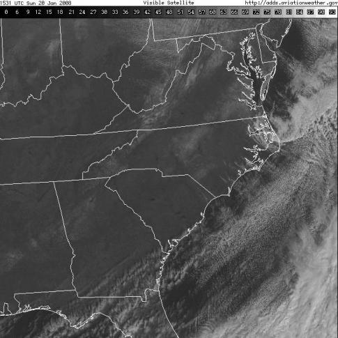
Finally, we had an interesting brush with winter weather this weekend, one in which most of us ended up with disappointingly small snowfall accumulations that ranged from just a trace to around half an inch over most of the area, with a few small streaks where one half to one inch were reported. Forecasts indicated higher amounts than that, but while most of the ingredients in the forecast proceeded very nearly as expected, cold air drifting in from the west was about 4 hours or so slower than projected in causing a changeover from rain to snow at the surface, allowing a greater fraction of our precipitation to reach the ground in liquid form. Nonetheless, it made for a pretty sight falling by Saturday afternoon and evening, and left behind just enough of a white coating to be visible from space on Sunday morning after our skies cleared out. If you enlarge the attached satellite photo (from 10:30 am on Sunday) by clicking on it, you can see where snow cover was left behind over central North Carolina and eastern Virginia from Saturday's event, along with some snow cover over western parts of our state that was left over from the previous round of wintry weather last Thursday morning.
Copyright 2024 by Capitol Broadcasting Company. All rights reserved. This material may not be published, broadcast, rewritten or redistributed.


