
...CoCoRaHS! Okay, the old song by Little Anthony & the Imperials is actually "Shimmy Shimmy Ko Ko Bop," but I can't seem to see the acronym CoCoRaHS (which stands for Community Collaborative Rain Hail and Snow network) without that tune popping into my head.
CoCoRaHS is a nationwide program based out of Colorado State University to enlist a network of observers who can make and report accurate measurements of precipitation that are collected on a daily basis, and then made available to the public and to researchers and operational meteorologists studying the variability of precipitation, assesing storm impacts on agriculture and water supplies, validating radar and computer model precipitation estimates, verifying techniques for predicting or sensing hail sizes, and so on. The program includes having observers acquire and properly site a standardized, quality rain gauge and even includes the purchase or production of "hail boards" that can make a record of the size of hailstones that fall from strong thunderstorms.
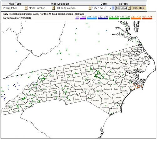
The program began back in 1998 but did not reach North Carolina until recently. It is now active on our state, however, and is seeking new volunteers. It is also making data available for our state, including the map above on which you can get an idea of the amounts of rain that occurred Saturday and Saturday night as a large, complex storm system made its way northeast across the region. We picked up some very beneficial rains, including specific CoCoRaHS observed amounts like1.32 inches just west of Apex, 1.5 inches just south-southwest of Garner, 2.08 inches a few miles northwest of Kenly, 1.92 inches in Wilson, and so on. You can see a color coded overview of rainfall amounts from this system on the attached map (which also gives a good idea of how the new reporting sites are distributed around the state - there is a clear need for more volunteers in non-metropolitan areas across the northern Piedmont, Northern Coastal Plain and the entire southeast corner of the state).
At the actual CoCoRaHS web site, you can select a map like that for any date, and then click on it to zoom to county level and see specific rainfall values instead of the color-coded dots. If you're interested in either using the data there or in being a part of the network, you can find all the details at
http://www.cocorahs.org/
The other possible reference to "shimmy" in this post would be the trees on Sunday afternoon, as strong winds set in behind this weekend's storm system. Peak wind gusts around most of our viewing area ran between 35 and 40 mph, but with 42 mph gusts at Pope AFB and Roanoke Rapids, while to our east and west Elizabeth City had a 46 mph gust, Wilmington a peak of 47 mph and Greensboro recorded a gust to 49 mph.
Copyright 2024 by Capitol Broadcasting Company. All rights reserved. This material may not be published, broadcast, rewritten or redistributed.


