More Rainfall Follow-up...
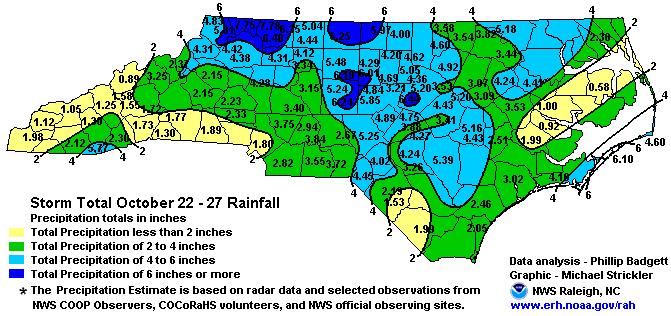
Today, the Raleigh National Weather Service has posted some additional details regarding specifically the 24-27 Oct 07 rainfall event, with both a text listing of "storm total" rainfall amounts and a contour map based directly on those rain gauge readings.
Posted — Updated
In yesterday's post, I showed a rainfall map and discussed some lake responses relating to the copious (and much-needed) rain that fell across much of the state during the latter half of last week. The map used in that post actually showed rain totals for a two-week period, based on radar estimates that had been subjected to a consistency check against gauge totals.
Today, the Raleigh National Weather Service has posted some additional details regarding specifically the 24-27 Oct 07 rainfall event, with both a text listing of "storm total" rainfall amounts and a contour map based directly on those rain gauge readings. I've reproduced the map here, and you can also access it at
http://www.erh.noaa.gov/rah/news/content/precip.20071027.gif
The text listing is available at
http://www.erh.noaa.gov/rah/news/content/RDUPNSRAH.20071027.html
and includes an invitation to join a recently developed precipitation reporting network called CoCoRaHS (Community Collaborative Rain Hail Snow network), which some of you might be interested in.
Unfortunately, our prospects for adding to those totals in the short term still look poor. While a few spotty sprinkles or showers wouldn't be impossible late Wednesday night into midday Thursday across the eastern half or so of our viewing area with the passage of a cold front and weak upper level trough, the chances appear good that most of us will simply see a few more clouds during that period, followed by a return to cooler temperatures and more sunshine late in the week.
Copyright 2024 by Capitol Broadcasting Company. All rights reserved. This material may not be published, broadcast, rewritten or redistributed.


