
After a couple of brief breaks from heat and humidity across the region on Thursday and again Saturday, we're heading into a stretch this week that will feature temperatures that run a little above normal, with low to perhaps mid 90s common around the area through Thursday or so, and will also feature fairly high humidity levels thanks to persistent south and southeast winds around the west side of a typical Bermuda High pattern now in place over the western Atlantic.
That high, together with a building ridge aloft over the eastern U.S., should acto to suppress shower and thunderstorm activity over the next several days, although with some low level moisture in place and very warm surface temperatures, we can't entirely rule out the odd afternoon or evening storm in spots.
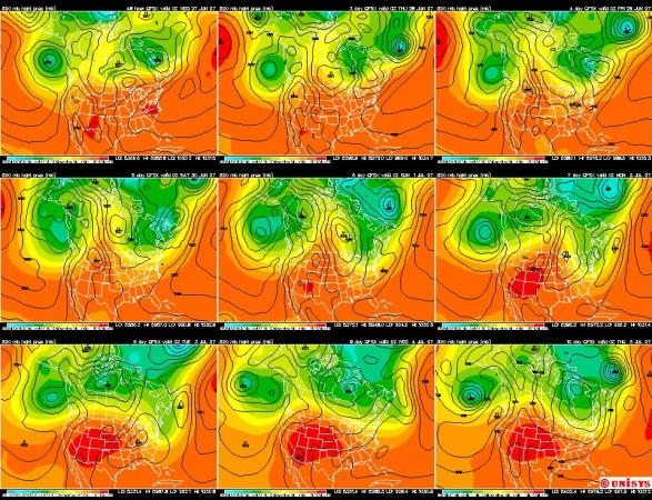
They may become a little more organized and widespread st times later Friday into Saturday, as a cold front pushes into the area from the northwest, and that front should also bring us a break from the heat as it appears a fairly deep upper level trough will develop across the northeastern U.S. this weekend into early next week. Although it's a little soon to have a great deal of confidence about model results that far in advance, I've attached a nine day forecast from the GFS (Global Forecast System) model from the Unisys weather web site that shows surface pressures in black outline and the height of the 500 millibar surface, which acts as a pretty good analof to pressures at around 18,000 feet above the ground, or about halfway up in terms of atmospheric mass.
Early on you see a pattern with an upper ridge (orange colors) across the eastern U.S that gives way toward the weekend to a developing trough indicated by the extension of the "cooler" colors down into the northwestern Atlantic and along the eastern seaboard. While these colors represent the height of a pressure surface, they also indirectly give a feel for temperatures at the mid-levels of the atmosphere and below, and help to indicate a downward trend in our temperatures, and especially those to our north and east, this weekend into early next week. At the surface, a pair of troughs followed by hgih pressure centers to our north and west indicate likely frontal passages late Friday into Saturday, with a reinforcing front possible late in the weekend.
All of that is also reflected by a Climate Prediction Center temperature outlook for the 6-10 day period, which shows a trend toward above normal temperatures off to our south and west, with a good chance at below normal readings on average from here northeastward.
While it's still early for many specifics, it wouldn't be a surprise to see the low and mid 90s of this week give way to low and mid 80s for a few days instead, and perhaps a day or two where parts of our area struggle to reach 80.
Copyright 2024 by Capitol Broadcasting Company. All rights reserved. This material may not be published, broadcast, rewritten or redistributed.


 for 2024 season")


