
A week ago in this space I mentioned a big turn toward unseasonably cold weather coming up for the Easter weekend, and it turned out to be a case where the longer range computer model projections that led to those forecasts panned out rather nicely, and accurately indicated the potential for an airmass cold enough to keep our highs mainly in the 50s and to allow for a night or two with lows in the 20s. There were also minor hints at sprinkles and flurries that far in advance (last Monday), but the chances appeared very slim until about Wednesday when the various models began indicating moisture associated with a passing upper level disturbance and a weak surface low might be substantial enough for some measurable precipitation to develop. Asa result, WeatherCenter (and other) forecasts through the latter half of the week included a mention of patchy rain and possible snow for late Friday night.
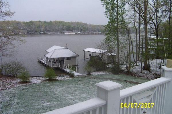
In the end, we got about 13 hundredths of an inch of precipitation at RDU from this event, with a trace of snow included, and in some parts of the northern half of our viewing area, the snow was enough to briefly leave a white coating on the ground and elevated objects. Of course, with daytime temperatures heading into the upper 40s and soil temperatures very warm after last week's 80 degree-plus highs, the snow didn't hang around very long at all. While it was here, a few people e-mailed me some photos, and I've included a couple of those above. Just click on the arrows to step through the images, and remember any image can be enlarged by clicking on it. In a historical sense, a trace of snow at RDU on Apr 7th is unusual in that it hasn't happened there since the airport records began in the 1940s. On the other hand, we have had a trace of snow reported there on Apr 5th, 13th, 17th and 19th in the past, along with 3 tenths of an inch on Apr 11th in 1989 and 1.8 inches on Apr 18th, 1983. We also had a trace of snow at another reporting site in the Raleigh are on May 2nd, 1939. Lastly in terms of records, we dipped to 27 degrees at RDU on Easter Sunday morning, a new record low for Apr 8th, breaking the previous mark of 28 last reached in 1978.
We're still well on the cold side of our normal highs of around 70 as we're kicking off this week, but it appears we'll see a recovery in temperatures this week, especially by Thursday afternoon and Friday, as highs drift into the 70s. There may be a one day interruption in our warming trend on Wednesday, though, as low pressure forming southeast of the state appears as if it will combine with a ridge of high pressure to our northeast to hold a shallow cool airmass in place over central and western North Carolina. If the system is also able to work with an upper level trough forming to our west and keep our skies mostly cloudy to cloudy, and to produce a few periods of rain as we currently expect, we may see highs in the 50s Wednesday after having climbed above 60 degrees under a bright mix of sun and fair weather clouds on Tuesday.
Copyright 2024 by Capitol Broadcasting Company. All rights reserved. This material may not be published, broadcast, rewritten or redistributed.


