
By Mike Moss
Last week I mentioned the potential for a shift to mainly normal to above normal temperatures setting in for the middle and end of this week, and so far we appear to be on track for that to occur, although as usual there is some disagreement beyond the next couple of days among computer models as to whether we will hover just a little on the warm side of normal (mid 50s or so this time of year) or swing beyond the usual departures from normal into the upper 60s to around 70 or so. In all cases, it appears we'll stay too warm into the weekend for any frozen precipitation.
There was actually a little of that over the northeastern half of our viewing area Sunday afternoon and evening, as we closed out the weekend with the passage of a strong, but moisture-limited upper level disturbance that swept southeastward across the area accompanied by very cold air just a few thousand feet off the ground. This destabilized the air yesterday afternoon and caused a layer of clouds to develop for a few hours. The fact that those clouds were at the correct temperature for rapid growth of dendritic snow crystals helped them to develop precipitation sized particles that led to plumes of radar echoes drifting toward the southeast, but the cloud bases were around 5-8,000 feet above the ground and dry air below prevented much if anything in the way of surface sprinkles or flurries around here. I was able to find a brief period of light snow at the surface last evening reported at Currituck, and a few likely flurries at Cape Hatteras closer to midnight. The same system helped to enhance already blustery winds across the area late yesterday, and we had wind gusts to 35 mph at Fayetteville, 40 mph at Raleigh-Durham, and a 45 mph gust at Greensboro, while sustained winds (2-minute averages) mainly ranged about 12-20 mph.
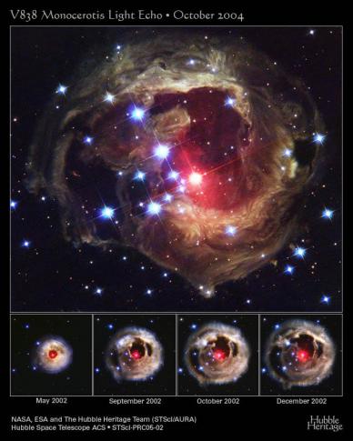
Occasionally, we like to throw in a reference to something a little off-topic here, but that we find interesting. That is what the "Bouncing Light" in the title speaks to, as well as the image above. It is something I ran across while browsing a Hubble Space Telescope gallery, and involves a series of images taken a few years back by the Hubble of a star, about 20,000 light years from us, that inexplicably expanded for a brief time, became the brightest star in the Milky Way, and then subsided, all without shedding mass as astronomers would expect of a Nova. Once this had happened, an expanding spherical "shell" of bright light continued to flow away from the star, and then to reflect off of successive layers of dust in the space surrounding the star. These "light echoes" made for a fascinating series of images, and some astronomers likened the event to being able to see a "CAT scan" of the dust in the vicinity of the star. Here are some links to more resources about this event for those who are interested:
http://hubblesite.org/newscenter/archive/releases/2005/02/
http://www.space.com/scienceastronomy/light_echo_030326.html
Copyright 2024 by Capitol Broadcasting Company. All rights reserved. This material may not be published, broadcast, rewritten or redistributed.


