
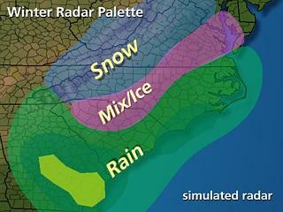
MIKE MOSS SAYS: Louis, That's a pretty close estimate on your part. This time of year, we have a so-called "Winter Palette" that is applied to national and regional radar imagery.
The image above roughly illustrates the meaning of the colors on our wintertime radar displays. Areas that have a blue shading indicate precipitation that is snow or mainly snow, pink areas indicate either freezing rain, sleet or a wintry mixture of differing precipitation types, and the various shades of green, yellow and red have their usual meaning as increasing intensities of rainfall.
Please note that the radar itself typically cannot discriminate between precipitation types. Thus, the colors are based on a combination of surface observations and computer model estimates of vertical temperature structure in the areas where precipitation echoes are detected, and the exact locations of snow/ice/rain boundaries are imperfect, but reasonable approximations.
Copyright 2024 by Capitol Broadcasting Company. All rights reserved. This material may not be published, broadcast, rewritten or redistributed.


 for 2024 season")


