
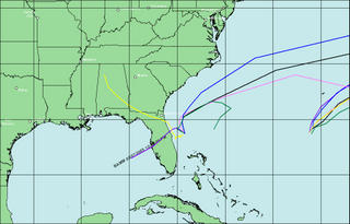
Folks at the National Hurricane Center in Miami are scratching their heads over where Tropical Storm Ophelia will head over the coming days. Below is just a comparison of the models used in tracking tropical systems. Notice how there is a wide disparity among them. Two of the models are outliers that take Ophelia into the Gulf and into north Florida.
Steering winds aloft are light so there isn't really anything that can move Ophelia. Also there is a surface high sitting to the north over the Carolinas that would prevent a northward track in the short term.
Perhaps the reason why many of the other models carry Ophelia deeper into the Atlantic is an upper level trough that is forecast to come along and pick up the storm and carry it away. Only time will tell and you know we will be watching this closely.


