
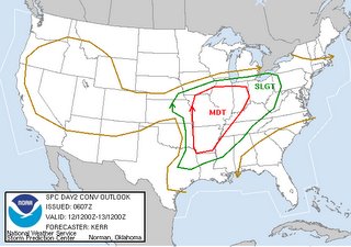
This weekend brought a major outbreak of severe weather to the eastern Plains and mid-Mississippi Valley, and it seems worth a tip of the hat to the group of weather forecasters that make up the Storm Prediction Center (SPC) in Norman Oklahoma. Both on Saturday and early Sunday, a quick scan of computer model output would indicate rather little in the way of widespread or heavy rainfall in the vicinity of Oklahoma, Kansas, Missouri and Illinois. However, there were clues in place regarding moisture content, vertical temperature profile patterns and associated levels of instability, placement and intensity of surface low pressure centers and frontal boundaries, wind directions and speeds in the lower and mid-levels of the atmosphere and the resulting wind shear profiles, and more that were interpreted by SPC in such a way as to lead them to forecast, on Saturday morning, a moderate risk of severe thunderstorms for the middle MS valley area, and then early Sunday to upgrade that forecast to a high risk, centered over Missouri and western Illinois. The forecast outlooks from Saturday morning and Sunday morning, both valid for Sunday afternoon and evening storms, are shown here.
As it turned out, there were some 110 tornado reports, including some 28 injuries and at least six fatalities, along with a substantial number of serious damage reports. This is without doubt a tragedy for all those affected, but with such an energetic outbreak, one has to think that the injury/fatality count may have been higher in the absence of such an accurate assessment of the impending situation by SPC and that their efforts likely saved some lives. A preliminary map of coded storm reports is shown below, and you can always go back and retrieve these kinds of maps, paired with text descriptions of each report and its city/county location, for any date in the past few years at the SPC archived storm reports page.
The same weather system is likely to produce more severe weather today, shifted more into the Ohio Valley. It will also push a cold front through North Carolina late tonight and early tomorrow that may trigger some showers and gusty thunderstorms. It appears at this point that our chances of severe weather with this system are minimal, and that rainfall will not be as substantial as we might like given the moderate drought conditions in place, but if storms do form they will have the potential to produce wind gusts in the 40 - 50 mph range.


