
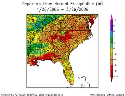
That's an impossible question to answer with certainty of course, but we do seem to be transitioning into a pattern for the next 10 or 15 days that would favor temperatures at or above normal, while precipitation is likely to be in the normal range or below, which isn't terribly promising for cutting into rainfall deficits across the area. Below is a map from the Southeast Regional Climate Center showing 60-day rainfall anomalies for NC and surrounding states. You can see similar maps covering time spans of 7, 30, and 90 days by clicking here.
For those of you who are winter weather fans, it does make some recent flurries and patches of sleet around the region, last Monday and Tuesday and also in isolated pockets toward the north this past Saturday, quite possibly our last brush with frozen precipitation this season. After several days with temperatures running well below normal, and still seeing most of the precipitation that occurred fall in the form of rain, the chances of snow will be reduced even further if the expected warm anomolies set in for the next couple of weeks.
From a historical standpoint, that doesn't mean we have absolutely no chance at all of further wintry weather. A scan of records for the Raleigh-Durham airport, and the series of official Raleigh reporting sites that preceeded it stretching back to 1887, shows that our latest measurable snowfall occurred when 1.8 inches fell on April 18th in 1983, while we've recorded an unmeasurable flurry as late as May 2nd in 1938. In more recent years, we did record a trace of snow on April 17th in 2001.


