
... That being a low pressure wave on a frontal boundary to our south that set up over the course of the weekend and left us with another welcome soaking across central and especially southeastern portions of our viewing area. A cold front that crossed the state with a little rain and some strong storms on Friday stalled to our south Saturday night into Sunday, while an approaching upper level trough helped to generate and intensify a suface wave of low pressure along the front that moved through a little to our south and east in a favorable position to produce widespread, moderate to heavy rains across the state, while also locking in a shallow wedge of rain-cooled air that kept many of us in the 50s much of the day on Sunday, with a daytime high of 59 degrees at RDU (that's not a record, by the way, as our coolest May 7th featured a high of 49 in 1992. We do have a chance at setting a new "record low high" today, May 8th, as we're expecting a high of no more than 60 degrees, while the coolest May 8th on record was a 63 degree day in 1956).
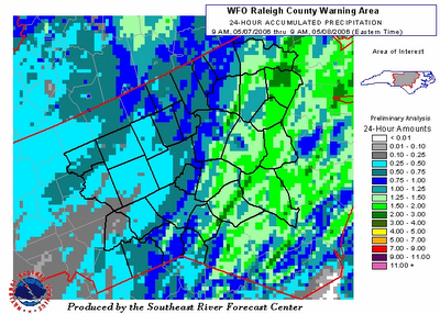
Here's a map from the Southeast River Forecast Center showing combined radar and rain gauge rainfall estimates for Sunday into Sunday night. You'll see a gradient from around .25-.75" toward the northwest to around 1-3 inch totals toward the south and east.
For another graphical look at rainfall totals over selectable time frames, see this site recently developed by the National Weather Service. It's an interesting feature to play around with.
Finally, here are some selected Sunday-Sunday night totals in inches from around our viwing area, reported by airport weather stations and/or NWS cooperative observers: RDU .77, Fayetteville airport 1.72, Burlington .77, Chapel Hill 1.03, Sanford 1.21, Lumberton 1.99, Rocky Mt-Wilson 1.04, Clinton 1.94, Oxford 1.26, Asheboro .75, Smithfield 1.47, Roanoke Rapids 1.34, Siler City .75, Southern Pines .95, Raeford 1.25.


