Ah despite Sunday being a very chilly day, we did receive a widespread much needed rainfall. Much of the viewing area saw at least an inch of rain. Many locations south and east of Raleigh saw 2" or more of rain. RDU unfortunately (as Mike Moss told you in his previous blog entry) only saw .77" of rain. The deficit at RDU now stands at 4.56" and at Fayetteville 5.35".
Now that the storm has departed why hasn't the cloud cover moved out? The graphic below explains what is going on. We had a cold air damming situation set up in the atmosphere. At the surface, we have a cool, moist (although it is relatively drier than the flow from the southwest) flow of air. Aloft on Sunday there was a southwest flow of air. This warmer moist air overrunning this cooler air mass helped to develop the low overcast and rain. With low pressure moving south of the area, this aided in lifting the air and developing more rain. Now that the low has departed we are left with a shallow cool pool of air that extends from the surface to about 5,000ft into the atmosphere.
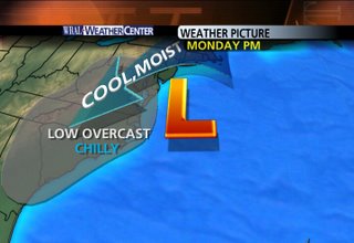
The Monday afternoon graphic shows low pressure moving farther into the Atlantic Ocean. The flow around the low is in a counter-clockwise fashion. This has kept the flow of cool,moist air into the region supporting the low clouds and drizzle.
The Tuesday morning graphic shows the flow still from the north and northeast continuing to support the low clouds, drizzle and hence cool temperatures.
Cold air damming is one of the hardest features to forecast in North Carolina. It is very difficult to tell exactly when this wedge of cool air will break. Usually a strong southwest wind will break the wedge and clear the skies, but since Tuesday's winds will remain northerly, there is the likelihood that the wedge won't break but just become more shallow. This means we could see clouds the entire day with spotty drizzle and of course chilly temperatures.
If the clouds do not break Tuesday, they will not break until we experience a change in air mass. This exchange would come from a warm front that will bring more clouds and the chance for rain Wednesday afternoon.
Behind that warm front is a cold front that moves into the area on Thursday. It will also bring more clouds and the chance for showers and storms.
The bottom line here is, we may not see a return to full sunshine until Friday when high pressure builds in and helps clear the skies.
So in the meantime I hope you like the color gray since we may be seeing quite a bit of it in the coming days.