
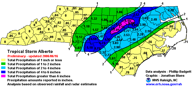
An extreme event like the heavy rains and flash flooding associated with Alberto's remains as it crossed our area (see the NWS rainfall map below, from a report on Alberto at the Raleigh Forecast Office Web Site) always leads one to wonder where the event stands in relation to others and in terms of its historical likelihood.
A new tool called the Precipitation Frequency Data Server (PFDS) operated by the NWS Hydrometeorological Design Studies Center provides a wealth of information to address this topic. Of course, as in any statistical application, the numbers involved have to be interpreted with caution, but can give some sense of the probability of selected amounts of precipitation over a given amount of time.
In the case of Alberto, the rain that fell at the RDU airport, for example, can be compared against estimates based on all previous rainfall records from that site, and show that roughly speaking, the 5.65" that fell in Alberto within 24 hours (5.64" of which occurred on the calendar day 14 June, which barely broke the previous "official" calendar day rainfall record of 5.63" for Raleigh set back in October 1929) has about a 20-year return interval. However, closer inspection of the rain records from that day show that about 5.26 inches of that (some 93%) fell within a 6-hour period from around 7 am - 1 pm. According to the PFDS, this would be about a once in 150-160 year event. Of course, there are other parts of Wake County that received around 7 inches of rain from Alberto, and depending on how concentrated that rain was in time, the return interval may be notably greater than 150 years.
Here is a graph from the PFDS that can be used to estimate the return interval, calculated for RDU, for a given rainfall amount over a set period of time:
In the graph above, for example, the black curve indicates a 100-year average recurrence interval. For example, one would expect about 7.3 inches of rain to occur over a 24-hour period about once in that span of time, while for example, the magenta line shows that one would expect just over 4 inches of rain in a 6-hour period to occur about once in 25 years.
Next is a graph from the PFDS of seasonal probabilities of heavy rainfall events over a 1-hour period, showing that very heavy rain over such a short time is focused in the summer months when slow moving systems (usually thunderstorms) are fueled by unstable air and very humid airmasses:
A similar graph for 2-day rainfall amounts is skewed more to late summer and early fall, due to the dominance in heavy rain events over that long a time of tropical systems that tend to impact our region most frequently in those months, with a secondary summer maximum that still reflects heavy thunderstorms and early tropical systems, and finally a small peak in the late winter/early spring associated with mid-latitude storm systems that begin to tap into greater amounts of humid air as temperatures warm heading out of winter and into the spring:
If you'd like to explore the PFDS for your own location, you can click the map at any point to generate interpolated data for that spot, at http://hdsc.nws.noaa.gov/hdsc/pfds/orb/nc_pfds.html.


