
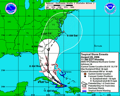
The answer to the title question remains in great doubt, of course, since I'm writing this at midday Monday and the most recent NHC forecast fan for Ernesto (below) indicates the storm may eventually drift out over the Gulf Stream in an environment that could allow it to make a slow pass across eastern parts of our state late Thursday into Friday night, potentially as a category one hurricane. Of course, it's always worth remembering that historical average errors in position and intensity are quite large that far in the future, and it remains possible that Ernesto could track our way on an inland path, or could recurve far enough out to sea to have little or no impact on the state.
In that regard, we've already seen track forecasts make a dramatic eastward shift in the last two days, as long range model output on Friday and early Saturday was quite consistent in moving the storm center into the middle of the Gulf of Mexico. Now, the model solutions cluster along a track that would bring the storm up through eastern Florida Wednesday. Will the track continue to evolve eastward, or will it stabilize as currently forecast? A lot depends on how a fairly strong upper level trough digging into the Plains states today affects a deep but weakening mid-upper level ridge of high pressure that has lingered across the southeastern U.S. for several days. Earlier forecasts indicated minor weakening of that ridge and significant strengthening of Ernesto, making it somewhat subject to steering around the southwest periphery of the high. Now the high looks as if it will break down more rapidly, and for the time being Ernesto is a weaker system, more subject to shallower steering currents that could push it toward the north for a while.
Just to complicate the picture a bit more, there is a stationary frontal boundary north and west of us that has been producing showers and storms through the plains, midwest and northeast for the past few days. It appears that front will be shifted southeast ahead of a fairly strong surface high that should set up over eastern Canada by midweek (a Global Forecast System map below shows model output for 2 pm Wednesday, with Ernesto over south Florida and a frontal trough cutting from northeast NC to western SC). The front itself should bring a small increase in our chance of showers and thunderstorms by late Tuesday and Tuesday night, and perhaps a better chance on Wednesday, along with some relief from the heat and humidity we've started the week with. Interactions between the approaching tropical system and the stalled front will make the forecast very tricky Thursday into Friday night, and we could very well end up with some bands of heavy rain over central and eastern NC, strong winds along the coast, and a large temperature contrast that could bring highs in the 80s near the coast and possibly 60s and 70s over the Piedmont. The second image below is a forecast from the National Hydrometeorological Center of 5-day rainfall totals ending at 8am Saturday, and indicates potential for 3-6 inches over the eastern half or so of our viewing area, and perhaps 5-10 inches along the coast, with amounts likely dropping off rapidly across the western half of the region.
A heavy rainfall event, within reason, wouldn't necessarily be a bad thing, as much of the area has fallen back into abnormally dry and moderate drought designations (the yellow and buff shaded areas on the map below, from the NC Drought Monitoring Council), and within those larger areas there are certainly some small pockets that are even drier. It is a common feature of North Carolina's hydrologic cycle for us to fall behind on overall rainfall through the summer's widely scattered thunderstorms, and then have water supplies and soil moisture replenished by the passage of two or three nearby or remnant tropical systems. It can be a double-edged sword, of course, if those systems also produce wind damage, tornadoes or flooding as they move through. While many different scenarios could still play out, here's hoping the frontal system moving into NC this week will end up keeping Ernesto's intensity on the low side, but allow it to move close enough for some much-needed significant rainfall for central sections of the state...
For those of you who like to dig into the details of model forecasts for tropical systems, there is a fairly new resource available in the form of a Tropical Models "e-wall" operated by Penn State University, with model output showing some important fields for tropical systems, like vertical wind shear, areas of sea surface temperature at or above 80 degrees, steering wind speed and direction and more, along with links to pertinent satellite imagery and more. You can check it out here.


 for 2024 season")


