Triad Tornado Tracks
The National Weather Service has completed their damage surveys of the May 8, 2008, tornadoes.
Posted — Updated
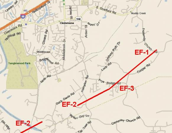
The National Weather Service offices in Raleigh and Greenville-Spartanburg completed their survey of the two tornadoes that struck the Piedmont Triad area on Thursday night. They determined that two tornadoes struck between 9:30pm and midnight on Thursday night.
The first touched down in Davie County, near Advance. It tracked northeastward, crossing the Yadkin River into Forsyth County. It lifted briefly, before touching back down and doing more damage in the village of Clemmons (your humble correspondent's hometown). Based on the radar data and the damage they surveyed, the NWS estimated the maximum winds in the tornado to be near 140mph.
This is considered an EF-3 on the new Enhanced Fujita scale. There were a couple of injuries, and a number of homes damaged or destroyed -- but, thankfully, no serious injuries or deaths.

Unfortunately, we cannot say the same about second tornado. One person was killed when the truck he was sitting in was flipped over as the tornado passed by. That storm tracked northeast along Sandy Ridge Road to near from near the I-40 split, then northeastward to near the Piedmont-Triad International airport. There, it tossed around a couple of airplanes. It also had its way with nearly everything that wasn't nailed down at the Farmer's Market on the south side of I-40. There were also a handful of injuries due to that tornado. Based on the damage, the NWS rated this tornado an EF-2, with maximum estimated winds of 130mph.

Copyright 2024 by Capitol Broadcasting Company. All rights reserved. This material may not be published, broadcast, rewritten or redistributed.


