Thousands without power after high-speed storms thrash NC
A ferocious line of thunderstorms raced through central North Carolina on Thursday, uprooting trees and snapping power lines with straight-line wind gusts up to 70 mph.
Posted — UpdatedMore than 150,000 people in central North Carolina were without power after the storms, including about 73,000 in Wake County as of 10 p.m., 23,000 in Johnston County and 19,000 in Moore County, according to Duke Energy Progress.
In Raleigh, trees and limbs came crashing down in the Hillsborough Street and Five Points areas – one large shade tree even toppled onto the patio of NOFO at the Pig restaurant on Fairview Road.
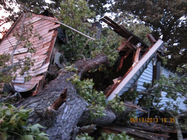
A pine tree smashed through the roof of Kelly Kopp's home off Wake Forest Road, damaging her master closet and bathroom. No one was injured.
"It's pretty much a humongous tree, laying diagonally over my house," she said, adding that she had a tree expert out about six months ago, who advised her not to cut it down.
"It survived hurricane after hurricane. You know, it's not coming down unless a tornado hits directly," Kopp said. "Lo and behold, it came down."
Katie Rogers narrowly escaped injury when a tree toppled onto her car on Glenwood Avenue.
"I heard this really loud noise. I saw a flash of light, and then I saw the tree coming from the corner of my eye," she said. "I just heard the loud noise when it hit my car."
The tree brought down a power pole, but Rogers was able to get out of the car safely.
In Cary, a 200-year-old oak tree smashed into a house on West Park Street downtown, while strong winds pushed over a tall pine, leaving it precariously cradled by power lines along Davis Drive.
Police closed Davis Drive between Hogans Valley Way and Caviston Way while utility crews worked to repair the damage.
Conner Sutton and Niklas Ehlin described loud, "crazy" winds in nearby Preston Village, where uprooted and snapped trees dotted the streets.
"I was just amazed," Sutton said. "We knew it was loud and all that, but we didn't know something could happen like that."
"It was pure chaos. There were things knocked over everywhere," Ehlin said.
Minimal property damage was reported, authorities said.
Cleanup efforts in Chapel Hill began immediately after trees and limbs fell to the ground in the university town.
"Run, run, run, run, it's like we're just running in circles," said Warren Edwards with the town's public works department. "It's all over the town here, everywhere. We're doing our best to get it cleared."
A large tree upended onto West Franklin Street, blocking two lanes and disrupting traffic. Al Green saw the tree come down.
"It got dark out here. I came outside, looked over to the right and then I saw that tree falling – just up and left," he said.
The tree had not been cleared as of 11 p.m.
In western Wake County, the fast-moving storm blew debris and broke trees in two.
"It sounded like whistling, and it was really loud," said Kristine Whipple, who lives in the Arbor Creek neighborhood in Holly Springs. "I walked outside and all the trees were bent ... I got whipped by a bunch of leaves and came running back inside."
The Old Stage Road corridor was one of the hardest-hit parts of the county. A huge downed tree blocked the road near Woodlawn Drive for several hours.
Fayetteville got hit with a triple whammy of severe storms, but no widespread or significant damage was reported.
Problems are expected to continue into Friday morning. RDU officials suggest checking with airlines before coming to the airport for early morning flights.
That storm could whip up winds in excess of 70 mph.
Wake Technical Community College has canceled evening classes at Main Campus and Northern Wake Campus due to power outages.
Franklinton was also hard-hit and a house fire in White Level is believed to have been caused by a lightning strike, he said.
"Everything is calm here now," Jones said. "We're in recovery mode."

"The most dangerous part of this system is before the heavy rain begins to move in," he said.
The storm's track puts strong wind gusts in downtown Fayetteville in the coming minutes, if not already.
More than 4,500 people are without power there.
The strongest part of the storms are now over Smithfield, but the worst is over for Durham, Chapel Hill and Roxboro, meteorologists said.
More than 2,000 customers lost power in Morrisville, as well as about 1,100 in north Raleigh and 1,400 in southern Wake County.
A cold front moving in behind the storm system has caused a 30-degree temperature spread across the WRAL viewing area. Temperatures in Roxboro at 6 p.m. were in the mid 60s, while, in Fayetteville, temperatures were still sweltering in the mid 90s.
More than 7,000 Duke Energy Progress customers in Durham alone have lost power, the utility said.
Orange County is no longer under a severe weather threat, according to the National Weather Service.
Severe thunderstorm warnings issued for Harnett and Lee counties until 6:45 p.m. Alerts for Chatham and Wake counties were extended until 6:45 p.m.
The severe thunderstorm warning for Person County has been canceled.
"Severe thunderstorm warning doesn’t sound as bad as tornado warning. But there are cases where severe thunderstorms have whipped up winds in excess of 100 mph," he said. "You need to take them just as seriously as a tornado warning. Don’t put your guard down."


• Credits
Copyright 2024 by Capitol Broadcasting Company. All rights reserved. This material may not be published, broadcast, rewritten or redistributed.


