Island evacuations start as Earl strengthens
Hurricane Earl continued to strengthen Wednesday as it moved toward the Eastern Seaboard, prompting communities from North Carolina to New England to keep a close eye on the forecast.
Gov. Bev Perdue declared a state of emergency and warned people along the coast not to let down their guard, despite projections that the Category 4 storm will not make landfall there.
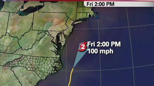
Earl, with maximum sustained winds of 140 mph, was about 520 miles south-southeast of Cape Hatteras as of 11 p.m. and was moving north-northwest at 18 mph.
"This storm is as strong as it ever has been," WRAL Chief Meteorologist Greg Fishel said. "The eye a perfect circle, and when you look at something like this, you know that this is a mean, mean storm."
Despite it’s strength, the National Hurricane Center says it's expected to fluctuate to a Category 3 storm still before it passes Cape Hatteras with winds around 115 mph.
The 11 p.m. track showed Earl slightly more off-shore than earlier models.
"I don't think we can close the books on a landfall despite what the official forecast is," Fishel said. "Even so, if a Category 3 storm goes just east of Hatteras, there will be some impact there."
A hurricane warning was in effect for all of the Outer Banks and Core Banks and extends from from the Bogue Inlet, north of Camp Lejeune, to the Virginia border.
Hundred leave ahead of Earl
As part of North Carolina's preparations, Perdue activated 81 members of the North Carolina National Guard and ordered an additional 151 to be on standby.
Swift-water rescue teams were also put on standby and the State Highway Patrol was called to assist with evacuations.
As of Wednesday evening, emergency management officials in Dare and Hyde counties had ordered evacuations of Hatteras and Ocracoke Islands on the Outer Banks.
Carteret County emergency management officials also announced a mandatory evacuation for visitors and residents of the Bogue Banks area from Atlantic Beach to Emerald Isle, effective 5 a.m. Thursday.
Hundreds of vehicles were backed up in traffic on N.C. Highway 12, the sole link between the Cape Hatteras Seashore and the mainland.
Emergency officials said they expect Earl to bring heavy rain, wind gusts up to hurricane strength and a 3- to -4-food storm surge that will likely create flooding on local roads, including the narrow N.C. 12, making travel unsafe.
Sgt. Jeff Gordon, a spokesman for the State Highway Patrol, urged people to leave storm-threatened areas well before Earl Hits.
"Some of the problems that we experience sometimes is when everybody tries to (leave) at one time," Gordon said. "This has been a highly reported storm. I hope that the public heeds the warnings and always takes precautionary measures as far as moving inland."
About 5,000 visitors and 800 year-round residents began leaving Ocracoke as a mandatory evacuation order took effect at 5 a.m.
Hyde County spokeswoman Jamie Tunnell said about 30 cars, including trucks pulling campers, were lined up for the 2½-hour ferry trip.
“Ferries are the only way off unless you have a private plane or boat,” Tunnell said.
The State Emergency Operations Center urged those leaving the coast to register with the American Red Cross "Safe and Well" program which helps keep familes and friends informed about one another during emergencies.
Earl's impact father south is still expected to be felt in the form of dangerous rip currents and beach erosion.
Red flags were flying high at Wrightsville Beach as a warning.
Ready for the storm
The Federal Emergency Management Association has sent a team to North Carolina to respond in case of any major damage.
“We're here for whatever Earl brings to the state. If Earl just bypasses us, then we'll pack up and go back where we came from,” FEMA federal coordinating officer Mike Bolsh said Wednesday. “If Earl does damage to the state, we'll do an assessment. If the President declares a disaster, we'll be able to lead the federal response to that recovery.”
Forecasters cautioned that it was still too early to tell how close Earl might come to land.
“A slight shift of that track to the west is going to impact a great deal of real estate with potential hurricane-force winds,” said Dennis Feltgen, spokesman for the National Hurricane Center.
The storm track has high stakes for the Outer Banks, where 120,000 visitors are expected for Labor Day weekend.
Calm before the storm
Just a light breeze was stirring and there wasn’t a cloud in the sky along the Outer Banks Wednesday.
Brittany Grippaldi and her family took advantage of the good weather to pack up their Ford Explorer in Hatteras and head home to New Jersey.
“It’s sad because reality hasn’t really set in because it is so beautiful out. It’s like, ‘Oh, I don’t want to leave this,’ but it’s like the calm before the storm,” said Grippaldi, who hoped to beat the traffic.
Chuck Costas also wasn’t taking any chances, interrupting his two-week vacation to move inland from the cottage he rented on Nags Head on the Outer Banks. Large waves already crashing ashore uncomfortably close to the home.
“It is what it is,” he said. “We have no control over it. If we lose a couple days, it’s not a huge loss.”
Also on Wednesday, the seventh tropical storm of the season formed far out in the Atlantic. Tropical Storm Gaston had sustained winds of 40 mph and is expected to strengthen into a hurricane this weekend as it moves toward the Leeward Islands.
Tropical Storm Fiona remained north of the Caribbean with winds of 60 mph and is expected to move toward Bermuda over the next several days.


