Helene on Friday brought a slew of tornado warnings to the WRAL viewing area, and a tornado touched down in Rocky Mount, injuring four people.
The storm caused deadly flooding in the North Carolina mountains beginning Thursday, and the central portion of the state saw the worst impacts midday on Friday.
Other WRAL Top Stories
At 2 p.m. on Friday, the storm had weakened to a tropical depression with the center of circulation between Tennessee and Kentucky with 35 mph winds. The massive storm will continue to bring rain and storms to parts of North Carolina before the state is "in the clear," but the impact of severe flooding, especially in the mountains, and tornado damage in Rocky Mount, could last for weeks.
Helpful links: Track rain with the DualDoppler5000 | See Helene's path | Sign up for WRAL alerts | Closings and delays | All watches and warnings
Friday was a WRAL Weather Alert Day as Helene delivered tornado warnings, flooding and power outages to the Triangle area and beyond.
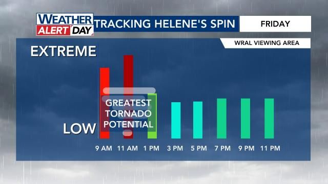
The Triangle and surrounding counties saw more than a dozen tornado warnings before 1 p.m., with Wake, Durham, Johnston, Chatham, Orange and others all in tornado warnings at some point. A tornado watch was in effect for the entire area until 6 p.m.
A confirmed tornado touched down in Rocky Mount along Benvenue Road and Tiffany Boulevard near North Wesleyan Boulevard. Four people were injured, and multiple buildings were destroyed, including a church and a Days Inn.
PHOTOS: Helene's damage so far
Alerts
- A tornado watch is in effect for much of central N.C. Numerous tornado warnings were issued.
- Flood warnings are in effect for Johnston, Sampson and Wayne counties. Dozens of counties also remain under flood watches.
- A wind advisory will be in effect for Alamance, Chatham, Cumberland, Durham, Harnett, Hoke, Johnston, Lee, Moore, Orange, Person, Sampson, Scotland and Wake counties on Friday between 12 a.m. and 6 p.m.
- Tropical storm warnings and watches are in effect for several western N.C. counties and Charlotte.
Helene brought 'catastrophic' flooding to western NC
Residents up in the North Carolina mountains experienced life-threatening flooding from Helene on Thursday and Friday.
On Friday morning, King Street in Boone was underwater. Viewers in the Triangle were sending in photos and videos of flooding and downed trees.
On Friday, Gov. Roy Cooper said, "with the rain they had already been experiencing before its arrival, this is one of the worst storms in modern history for parts of western North Carolina."
The governor warned the end of the rain is not the end of the threat, and floodwaters will continue to rise through at least Saturday.
"The priority now is saving lives," Cooper said. "Helene is causing life-threatening flash flooding, numerous landslides and downed trees, causing power outages. Flooding will continue through the weekend in some areas."
State emergency management director William Ray said cell service is failing in some areas of western North Carolina. Ray said 911 calls are being re-routed to other call centers while they work on bringing in equipment to bolster service.
The NCDOT said all roads in western North Carolina should be considered closed. Drivers are urged to stay off the roads unless there's an emergency.
The governor confirmed storm-related deaths in Catawba County and in Charlotte. There were more than 290 roads closed in the state.