DOT prepares roads for snow as school districts call for early dismissal Wednesday
Several central North Carolina school districts announced changes to their schedules for Wednesday in advance of a winter storm system that could drop up to four inches of snow in areas south and east of the Triangle, although flurries could fly here as well.
Posted — UpdatedJohnston and Cumberland counties announced that they would be dismissing students at least two hours early on Wednesday while Edgecombe County said students would be released three hours early.
The low pressure system that could bring the winter weather was forming near Florida late Tuesday night, but it was still unclear what track the system will take as it moves north.
"We don't know how exactly this is going to play out over the next 24 hours," said WRAL Chief Meteorologist Greg Fishel. “There’s still a chance that somebody could pull a rabbit out of their hat and get more than just a light tinting of snow in the Triangle, but right now the forecast is trending against that."
If the system takes a more westward path, then the threat of snow to the Triangle and southeastern counties increases. But if the weather system moves to the east and out along the Atlantic Coast, then the risk of frozen precipitation for the Triangle decreases, Maze said.
"It's really something we're going to have to watch hour by hour tomorrow," he said. "It’s possible we may not see much of anything in the Raleigh [if the storm tracks east]. If the low tracks farther inland, we could be looking at pretty decent amounts of snow in the Triangle area and along and east of I-95."
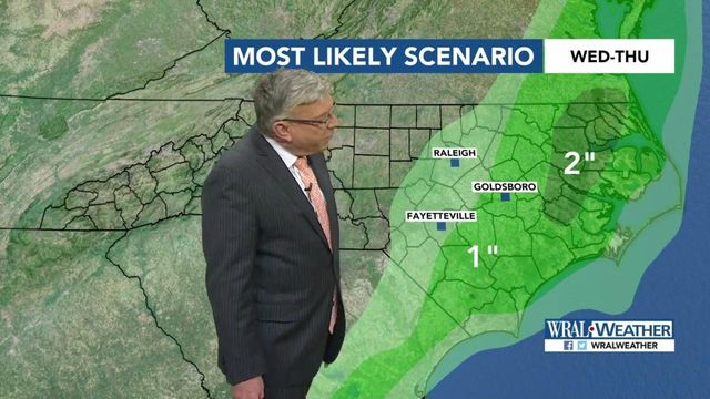
Fishel said the most likely scenario would have the Triangle getting a trace to 1 inch of snow, with higher amounts toward the coast.
Maze said the snow should begin late in the afternoon and pick up in intensity during the evening hours. The heaviest snow should fall between about 7 p.m. Wednesday and 1 a.m. Thursday, Fishel said.
One thing is for sure though, with freezing temperatures forecast for the rest of the week, any snow that falls in North Carolina will stick around for a while.
"The ground is so cold that whatever falls will stick and cause a problem," Maze said. "Thursday morning, we're just left with snow on the ground, slick roads and treacherous driving conditions. It'll be a problematic go at it Thursday morning."
The National Weather Service has issued a winter storm watch that goes into effect at 4 p.m. Wednesday and extends into Thursday morning. Winter weather advisories covering several counties, including Cumberland, Duplin, Gates, Edgecombe, Greene, Johnston, Onslow, Pender, Robeson, Sampson, Wayne and Wilson, begin at noon Wednesday.
"If you're close enough to the advisory area, you might as well count yourself as being in it, to be on the safe side, because of the uncertainty," Fishel said.
Several airlines, including American, Southwest and Delta, announced late Tuesday that they would waive change fees for passengers who want to delay air travel in advance of the winter storm system.
Roads ready for winter weather
Department of Transportation crews on Tuesday afternoon were busy preparing the roads for the potential winter weather.
Crews in Wake County began brining the roads at about noon and had planned to finish the job by 4 p.m., but as the day went on and forecasts shifted, those plans changed.
"They decided to take advantage of the extra time and stay out later than they had originally planned to get brine down because we don't know how many hours we'll have Wednesday to do it," said Steve Abbott with the DOT.
The work extended well into the afternoon hours, not only concentrating on the eastern part of Wake County as originally planned, but bringing the brine westward as well.
"Now, if you drove down Wade Avenue, it has brine on it. I-40 out towards Cary has brine. That wasn't in the original plan. We were going to try to hit that tomorrow," Abbott said.
Crews concentrated first on major roadways, bridges and overpasses, particularly in the eastern region. As of 5 p.m., 40 of North Carolina's 100 counties had done some sort of road treatment, 582 DOT employees were on the clock and more than 180 trucks had been on the road.
Now that the brining is done, crews are preparing for what could some along with snow.
"Bring them in as snow begins to fall. I don't know which forecast, some said afternoon, some said evening, bring them in and then they'll be in all through the night into the next day until the roads are clear," Abbott said of crews.
Abbott said a skeleton crew may be out brining for a short time Wednesday if temperatures permit, but crews brought in once snow begins falling would be focused on plowing efforts.
• Credits
Copyright 2024 by Capitol Broadcasting Company. All rights reserved. This material may not be published, broadcast, rewritten or redistributed.


