Satellite switch can complicate weather forecasting
After technical problems over the Atlantic, NOAA is shifting the position of weather satellites in space, a process that can take up to a month.
Posted — Updated
You probably didn't notice it during WRAL-TV weather segments but meteorologist across North America have had an additional challenge recently.
The quality of the images was degraded so much that a decision was made on Sept. 23 to take the satellite offline for more intensive troubleshooting. That left the National Oceanic and Atmospheric Administration (NOAA) with a single active weather satellite.
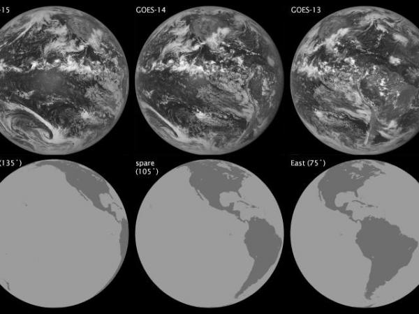
GOES-15 is parked at 135 degrees west longitude, over the Pacific Ocean and provides coverage focused on the west coast of North America.
NOAA immediately put GOES-West into "full disk scan mode" to help fill the gaps. This mode includes visible parts of the eastern United States not normally covered by that satellite.
For a longer term solution, the decision was made to activate a spare satellite put in place for situations like this. On Oct. 1, GOES-14 began moving from 105 degrees west longitude, south of the Texas-New Mexico border, eastward to take over the role of GOES-East. This is expected to take a full month to complete.
Weather satellites are in a geosynchronous orbit above the Equator. They fly at the same speed the Earth rotates which allows an unchanging, full-disk view of the Earth's surface. That's not just convenient for meteorologist to get the big picture of the weather, it's necessary to keep the satellites in orbit.
When you mix Newton's gravitational constant, the mass of Earth, the time it takes Earth to rotate once (4 minutes shy of 24 hours, but that's for another blog) and then subtract the radius of the Earth , you get a required orbital altitude of about 22,000 miles to keep a geosynchronous satellite in place.
At that altitude, moving 30 degrees west covers about 13,000 miles.
It also requires the satellite to speed up (Earth rotates from west to east, or counter clockwise when viewed from the North pole). All this takes a while.
As of Friday, GOES-14 had progressed about 10 degrees eastward at a rate of about 0.90 degrees per day. The plan is to move GOES-13 westward for additional troubleshooting. Project scientist Dennis Chesters of NASA’s Goddard Space Flight Center, described pulling off this satellite shell game as “changing your pants while driving your car.”
Copyright 2024 by Capitol Broadcasting Company. All rights reserved. This material may not be published, broadcast, rewritten or redistributed.


