NWS taking a step toward storm surge watches and warnings
When it comes to hurricanes, those "maximum sustained winds" get all the press, but the water is the big killer.
Posted — Updated
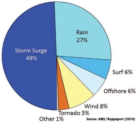
When it comes to hurricanes, those “maximum sustained winds” get all the press, but the water is the big killer.
Yet, hurricane watches and warnings (and their tropical storm counterparts) are keyed largely on what kind of wind a location is forecast to experience as a storm moves by. While people in hurricane zones can often ride out hurricane winds in a sturdy structure, those living in storm surge zones often need to evacuate to stay safe. The National Hurricane Center has long recognized this mismatch, and is in the midst of a multi-year project to improve how hurricanes are forecast and how those forecasts are shared with people in a storm’s path.

One result of that Hurricane Forecast Improvement Project was the creation of new storm surge maps. The new maps are designed to show a reasonable worst-case scenario of how deep the storm surge water could get during a given storm. Unlike previous storm surge forecasts, these maps show the depth of water above ground level at any one spot, rather than as a height above an average sea level value. This makes it easier to compare expected surge depth with flood protection measures.
Hurricane Arthur’s July brush with the N.C. coast was the first live test for those maps, and according to NHC Hurricane Specialist Robbie Berg, the maps did pretty well. During the National Weather Association’s annual meeting in October, Berg presented a recap that showed the maps performed well along the NC coast. 2014 was the first year of a two-year experimental run, after which the NWS will collect comments and evaluate the maps before potentially making the program a full-fledged operational product.
The next step for the NHC is folding that guidance into a formal storm surge watch/warning program. The storm surge watches and warnings would highlight areas with "a significant risk of life-threatening inundation by storm surge from a tropical cyclone”. Beginning in 2015, the NHC will generate maps highlighting areas that would be covered by a storm surge watch or warning. Like the surge depth maps, these will run as an experimental product for two years before potentially becoming a full-fledged NHC product for the 2017 hurricane season.
• Credits
Copyright 2024 by Capitol Broadcasting Company. All rights reserved. This material may not be published, broadcast, rewritten or redistributed.


