
That news never came Wednesday. Waters kept well within their proper places around the mall, but the news wasn't as good elsewhere.
A U.S. Geological Survey team measured the water level at the creek late Wednesday morning, and reported that it had actually gone down a few feet since dawn. There had been a flood warning issued for Crabtree Creek early in the day. Flood stage is considered to be 18 feet at Crabtree. Late Wednesday morning, the creek was running at 12.5 feet.
Most roadways were not badly flooded, but low-lying areas and many parking lots were. Lin Barbour runs a business near the mall. He told WRAL-TV5'sMark Robertshe didn't know what he'd find, but he had to bundle up and venture out to see.
While mall merchants had been concerned about business, they were relieved to see that there were only a few bad areas in the parking lot. Officials, who had planned to divert shoppers away from low-lying areas, say the are more relaxed since the water began to recede.
There was some fairly high water on Old Wake Forest Road, near Six Forks Road, which is another flood-prone area in Raleigh. But with early warnings about flood potential, auto dealers in the area were able to move their vehicles to higher ground before any damage was done.
The storm was causing serious problems Wednesday for residents of a mobile home park in Wilson. The Lincoln mobile home park was evacuated Wednesday morning as a precaution. That area has seen bad flooding in the past, and officials say residents could be out of their homes for days if the rain continues.
According to WRAL-TV5 MeteorologistMike Maze, there is a lull in store for the Triangle Wednesday afternoon, but there'll be more rain to come by afternoon and into the night. The area experienced some light-to-moderate rain Wednesday morning, after a Tuesday night deluge, but WRAL's Doppler 5000 Radar showed another line of heavy rain heading northward from the southeastern part of the state. Maze said he thinks the worst of the heavy rain is over, however.
The brunt of the storm was expected to be felt in Nags Head and elsewhere along the North Carolina coast, but the mountains were also looking at an accumulation of about eight inches of snow, following close on the heels of last week's two feet.
On the Outer Banks, surf churned up 6-to-8-foot swells, attracting adventurous surfers, and the storm was expected to be at its worst Wednesday afternoon. High tide was expected to bring waves up to 14 feet, and the possibility of flooding was real.
At least three school districts in northeastern NC cancelled classes because of the storm. Roanoke Rapids High School closed at 12:20 p.m. because of a power outage, and Edgecombe County schools planned to dismiss schools one hour early Wednesday and implement a one-hour delay Thursday morning. This is not a high tourist season along the NC coast, so it is year-round residents who are feeling the effects of this storm.
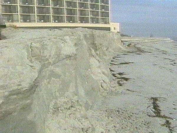
Wrightsville Beach residents consider themselves experts on riding out storms, but they know the power of erosion. They witnessed that power when the sun rose Wednesday morning. A great deal of sand was missing from the beach, especially along the northern stretch. Clem Sellers walks the shores of Shell Island. He told WRAL-TV5's Bret Baier the huge waves were washing over a row of sandbags.
Shell Island was badly hit by Hurricanes Bertha and Fran. This latest storm has weakened its defenses even more. Sellers says he thinks one more hurricane could erase Shell Island's beaches.
Many residents were watching anxiously to see how much more of their oceanfront property would be reclaimed by nature. ,Bret Baier,Ed Wilson
• Credits
Copyright 2024 by Capitol Broadcasting Company. All rights reserved. This material may not be published, broadcast, rewritten or redistributed.


