
Many area school systems, including Wake and Durham, have canceled Thursday classes.
Gov. Mike Easley declared a state of emergency in Wake County, and shelters were opened at the State Administrative Building at 116 West Jones St. and the Highway Building at South Wilmington Street
"It's a very unfortunate situation," Raleigh Mayor Charles Meeker said in an interview with WRAL's David Crabtree. "It's been a real nightmare for all of us."
Throughout central North Carolina, the snow fell from about 10:30 a.m. to 3 p.m. Person County received the most with 2 inches, Halifax County received an inch of snow and Warren County received 1½ inches. In Wake County, Cary got nearly half an inch and western Raleigh received nearly an inch.
Many area schools decided to close early, however, there are many reports from parents that their children were still at school because buses could not get to schools. Wake County schools suspended bus service at 9 p.m. Wednesday. The system estimated that about 3,000 students were stranded at 56 schools.
Buses will begin running again at 8:30 a.m. Thursday to take the stranded students home, or parents can pick up their children. The schools will serve breakfast to students.
Wake, Durham, Edgecombe, Franklin, Granville, Nash/Rocky Mount, Person, Northampton and Vance county schools will be closed Thursday. Chapel Hill-Carrboro, Johnston, Orange and Wilson county schools will operate on a two-hour delay.
Raleigh police say anyone who is stranded in his or her vehicle is reminded that it is not safe to stay in a car with its engine running. Carbon monoxide poses a significant poisoning danger under such circumstances. Raleigh Police Department patrol officers are on the lookout for stranded motorists and will offer appropriate aid. Anyone who is stranded and needs assistance should call 911.
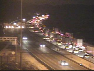
Some of the longest commutes and worst road conditions were reported on I-40, I-440, U.S. 64 East, U.S. 1 North and Durant Road.
The snow brought eastbound traffic on Interstate 40 into Raleigh to a standstill and halted travel on the city's I-440 beltline. Cars sliding on snow-covered roads caused accidents around the capital city.
The state Highway Patrol had received more than 200 reports of accidents in the area, mostly in Wake and Granville counties, from midnight until early afternoon Wednesday, said Patty McQuillan, a spokeswoman with the state Department of Crime Control and Public Safety. She said the patrol normally receives about 40 calls a day.
There were also eight reported wrecks on I-95 in Halifax, Nash and Northampton counties, though the Highway Patrol had no reports of fatalities or major injuries.
Durham police reported 150 accidents in a three-hour period early in the afternoon. Most were fender-benders with no serious injuries.
"The Highway Patrol has said the roads are extremely slick and that people should stay home or get off the roads," McQuillan said.
Colder temperatures moved in late last week. That system mixed with a disturbance in the jetstream, which brought precipitation from the Ohio Valley, said Mike Strickler, a hydrometeorologist with the weather service.
The winter weather was confined largely to the eastern part of the state. The weather service reported only a dusting in western areas, including the Triad.
"It's produced a little more just east of (Raleigh) than we anticipated," Strickler said. "A lot of systems dry up when they get east of the mountains, but this one is still cranking."
It was quite a change from last week, when temperatures reached the 70s in some areas.
Wednesday's accumulation was expected to remain through the night due to subfreezing temperatures, making for a difficult commute Thursday morning. Flurries could return Thursday, though temperatures were expected to reach about 40 degrees, the weather service said.
This weekend, the area could see more snow, but that forecast is far from certain.
On Saturday there is a chance of rain in the afternoon, possibly starting as a brief period of freezing rain or snow, the National Weather Service said.
Saturday night, there is a 50 percent chance rain, but there is a 40 percent chance of snow on Sunday morning, the weather service said.
"Saturday night we're likely to see rain developing and then late Saturday night into early Sunday morning we may see cold enough temperatures to change some of that into frozen precipitation, but it looks like amounts may be very light," said WRAL meteorologist Elizabeth Gardner.
If the area sees snow on Sunday, it will be the second consecutive Sunday. On Jan. 16, central North Carolina was surprised with a morning snow, most of which melted as soon as it hit the ground. Some areas near I-95 saw a brief accumulation.
Copyright 2024 by WRAL.com and the Associated Press. All rights reserved. This material may not be published, broadcast, rewritten or redistributed.

 for 2024 season")


